To develop or not to develop? That is the question framing biodiversity conservation

Isobel Bender u6673141 – 550 words

It is an unfortunate conundrum, that while biodiversity (diversity within species, between species and of ecosystems) is declining at a rate faster than any other time in human history, sites of high conservation value can also be ideal areas for urban and agricultural development. In turn, habitat modification continues to be a major driver in biodiversity decline.

This is the conundrum facing the Delma impar or the Striped Legless Lizard (SLL). The SLL is dependent on the critically endangered vegetation community of the Natural Temperature Grassland, 99% of which has been lost or altered since European settlement due its suitability as agricultural land. In August, I volunteered to help the ACT Parks and Conservation Service (PCS) in a conservation strategy that aims to address this conundrum and protect the SLL – the strategy of biodiversity offsets.

Delmar impar or the Striped Legless Lizard. Photo: Emily Sutcliffe 14th of October 2022

Biodiversity offsets – have your cake and eat it too?

Biodiversity offsets in Australia are designed to compensate for adverse impacts to protected matters like the SLL, which is listed as vulnerable under the Commonwealth Environmental Protection and Biodiversity Conservation Act 1999 (EPBC Act). In the ACT, several urban development sites negatively impacted the SLL and the developers were required to protect several areas with known populations of SLL (offset sites). PCS are required to manage these areas to ensure there is no further loss of habitat for the SLL.

In turn, the establishment of the offset sites are trying to marry the two contradictory pursuits – the need for development and the need for conservation – to ensure ‘no net loss’ of the SLL.

Tiles – home away from home

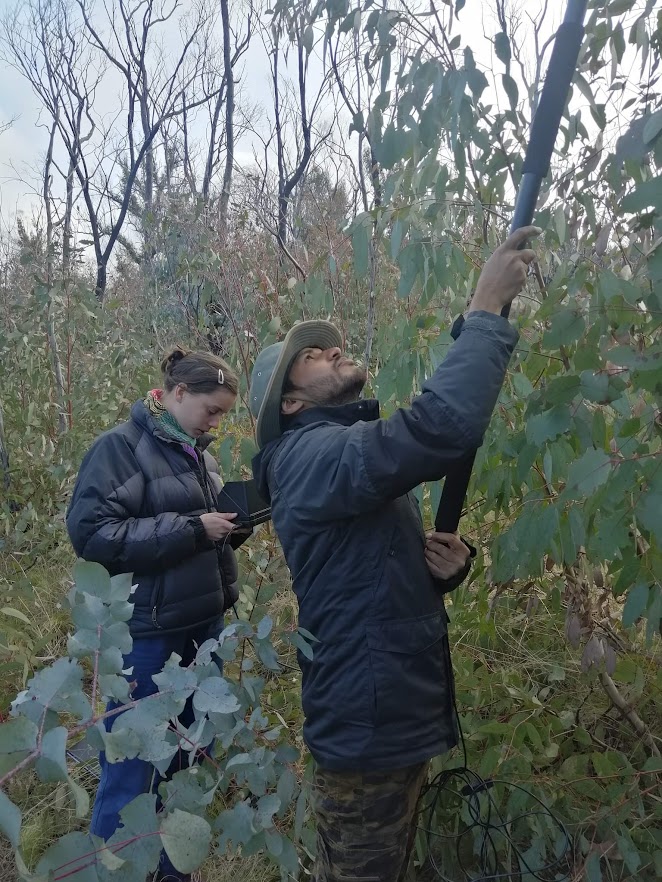
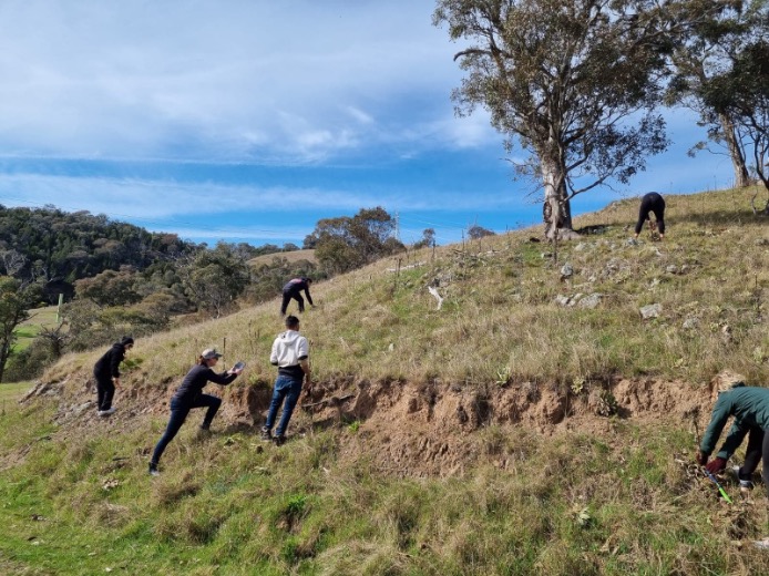
Part of the offset management strategy is to monitor the populations of SLL. This is where I came in. Over a couple of days, I worked out my muscles by carrying around 3kg roof tiles to set up monitoring plots. Within a monitoring plot, we placed 8 tiles in a square, with the tiles facing North and the darker side facing up to ensure heat conduction. The tiles are to create an artificial habitat to attract the SLL. Then in September through to December, the tiles are checked to record:

  • the percentage of tiles occupied by SLL and
  • the average number of SLL per plot.

This data is used to help detect any drivers of change in the population of SLL, anticipate any future changes and to inform management actions.

Example diagram of the tile setup to monitor the Striped Legless Lizard. Diagram adapted by author.

Closed loop or monitoring to death?

Biodiversity offsets is a controversial conservation strategy, where it is perhaps counterintuitive – there can be ‘no net loss’ in biodiversity while development detrimental to its continuance is approved. Yet this critique aside, while volunteering I found out the SLL population has continued to decline across the offset sites despite protection, management, and monitoring. This is also despite ACT Parks and Conservation identifying the driver of this population decline for two consecutive years as too intense grazing pressure within the offset sites.

This makes apparent that a conservation strategy alone is not enough to conserve biodiversity, and largely relies on an effective monitoring strategy.

Effective monitoring is meant to be like a closed loop – where monitoring data like population decline is linked to a particular driver of change and in turn, informs the effectiveness of a management action. This may trigger a change in management action, the results of which are monitored, and the loop continues. Unfortunately, monitoring strategies are rarely implemented in a way to ensure conservation success. Hopefully, PCS will make efforts to close this loop and adjust current management strategies to halt further decline of the SLL.

Example of an adaptive monitoring strategy for the Striped Legless Lizard. Diagram: author.
Striped Legless Lizard found under monitoring tile during 2022 surveys. Photo: Emily Sutcliffe 14th of October 2022
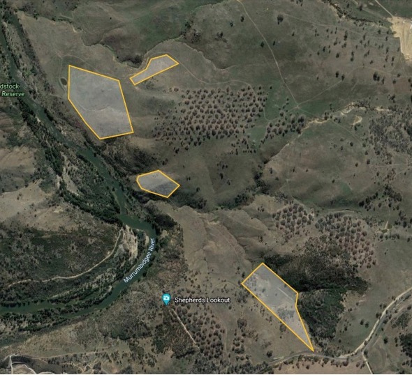
Note: The locations of the offset sites for SLL have not been referenced in this blog. The SLL is a threatened species and ACT Parks and Conservation service do not want to broadcast where the SLL are to minimise the risk of people checking the tiles by themselves and disturbing the areas. The monitoring method used is carefully thought out to minimise risks to SLL and other reptiles and has the required animal research ethics approval.

References

Convention of Biological Diversity 1992 (CBD)

Department of Climate Change, Energy, the Environment and Water (DCCEEW) 2022. ‘Delma impar — Striped Legless Lizard, Striped Snake-lizard.’ Available at: http://www.environment.gov.au/cgi-bin/sprat/public/publicspecies.pl?taxon_id=1649 (Accessed 25.09.2022).

Dixon, K.; Cary, G.; Worboys, G.; Banks, S.; Gibbons, P. 2019. Features associated with effective biodiversity monitoring and evaluation. Biological Conservation. Vol. 238. pp: 108221

Environment, Planning and Sustainable Development Directorate (EPSDD) 2015. ‘Striped Legless Lizard Delma Impar: Action Plan.’ Environment, Planning and Sustainable Development Directorate, Canberra.

Environment, Planning and Sustainable Development Directorate (EPSDD) 2020. ‘Environmental Offsets Ecological Monitoring Program Report 2018–19.’ Environment, Planning and Sustainable Development Directorate, Canberra.

Environment, Planning and Sustainable Development Directorate (EPSDD) 2021. ‘Environmental Offsets Ecological Monitoring Program Report 2019–20.’ Environment, Planning and Sustainable Development Directorate, Canberra.

Environment, Planning and Sustainable Development Directorate (EPSDD) 2022. ‘Offsets register.’ Available at: https://www.planning.act.gov.au/tools-resources/plans-registers/registers/offsets-register (Accessed 25.09.2022).

Gibbons, P.; Lindenmayer, D. 2012. ‘Biodiversity monitoring in Australia.’ CSIRO Publishing. Collingwood, Victoria. 

Intergovernmental Science-Policy Platform on Biodiversity and Ecosystem Services (IPBES) 2019. ‘Summary for policymakers of the global assessment report on biodiversity and ecosystem services of the Intergovernmental Science-Policy Platform on Biodiversity and Ecosystem Services.’ IPBES secretariat. Bonn, Germany.

Maron, M.; Ives, C.; Kujala, H. 2016. Taming a wicked problem: resolving controversies in Biodiversity Offsetting. BioScience. Vol. 66. pp: 489-498.

Miller, K.; Trezise, J.; Kraus, S.; et al 2015. The development of the Australian environmental offsets policy: from theory to practice. Environmental Conservation. Vol. 42. No.4. pp: 306-314.

Posted in Uncategorized | Leave a comment

Citizen Superheroes: We need you!

Maddy Saunders – U7114895

Setting

Citizen Scientists, you and I, are the future of data processing. Recently I spent a few hours being part of a team of superheros tasked with scrolling through picture after picture of koalas, birds and everything in between. Intrigued? Let me tell you how to get involved!

Your Mission, should you choose to accept…

DigiVol is a citizen science website which brings together a global community of volunteers who work to analyse and identify information from data samples, records or photographs. Citizen Scientists have been critical in processing an abundance of information which has gone on to populate and inform policy and research. DigiVol publishes a range of expeditions for public participation, I chose to participate in Koala surveying for the NSW Department of Environment and Heritage.

This project involved identifying mammals from photographs taken by camera traps to help develop a robust portfolio of species in Kosciuszko national park. Photos would be sorted into categories of either: koalas, wombats, bird, other mammal, other animal or human/artefact. This analysis helped understand the size of koala populations in this environment and to help identify threats to koalas in the same environment.

The Superpower you have been given!

Citizen Science allows data and research to be more accessible and more abundant. You get early access to research results for public projects. I found it so interesting to see just how many kangaroos were being caught on the cameras from the photos I was identifying. Even more so, how few koalas were showing up!

One of the friendly Kangaroos we got to ‘virtually’ meet!

Recently citizen science has also been used to revive historical samples and data records to further inform research. We are able to contribute to decades of research past by providing resources which previous teams may not have had the funding or time to allocate! 

Most importantly, DigiVol provides a platform for like-minded people to pick up and share new skills as a community. Citizen science projects have been loved by school-aged children with an interest in the field and retirees with a passion for this work.

No quest is without its challenges.

Camera traps are designed to blend into the surroundings and as such, the quality of images is not prioritised. Images can sometimes be unfocused, the wildlife may be out of site, or there may be some blockage in the way. However, DigiVol has your back. DigiVol provides a series of photos which capture the animals’ movements and different angles to assist in identification. There are also reference images in each sorting category to help appropriately match images. 

Author’s Reflection

Data and information are becoming more rapidly accessible as time moves forward. We have been given an incredible opportunity to access and contribute to significant scientific research GLOBALLY! It is incredibly fulfilling and exciting to be involved in such endeavours! David Attenborough once said:

“It’s surely our responsibility to do everything within our power to create a planet that provides a home not just for us, but for all life on Earth.”

So next time you have a spare 10 minutes, log onto DIgiVol, lend a helping hand to scientific research that’s making a difference! 

Posted in Uncategorized | Leave a comment

Hollow Homes: Are Avian Renters Using Affordable Homes in Namadgi National Parks?

Australia’s housing crisis has left many renters spending over 40% of their income on rent. In Namadgi National Park, 80 new rent-free homes have been set up with the support of the Bushfire Recovery for Wildlife and Habitat Community Grants Program specifically for hollow-dependent avian species. Despite the free accommodation and modern designs, some are questioning whether avian hollow-dependent species are actually using these homes. Now scientists are investigating nest-box use and the impact of the 2019/2020 bushfire on natural tree hollow availability.  

It was a sunny spring morning in late September of 2022 when I followed the two scientists and master students at the ANU, Nicole and Diego, into Namadgi National Park to investigate the situation. Our freshly hosed 4wd wound through Old Boboyan Road, the transect we would be collecting data on that day. We were met by a thick acacia and eucalypt understory, and clear evidence of fire in the remnants of a scorched overstorey (see image 1). Whilst as a protected area Namadgi National Park is able to minimise land-use and protect threatened flora and fauna by limiting pressures such as agriculture, forestry and hunting, some threats, such a fire, cannot be mitigated.

Image 1: Thick understorey regrowth and bare treetops indicate the high intensity of the fire that passed through this area. Photo author’s own.

80% of Namadgi National Park was scorched by the Orroral Valley Fire in 2020, having detrimental impacts on biodiversity of the protected area, according to the ACT/NSW Rapid Risk Assessment Team (2020). To support biodiversity in the post-fire landscape, 160 nest boxes were constructed, 80 of which have since been hung in the protected area. The nest-boxes are a variety of shapes and sized to suit different species of birds and bats.

To investigate the uptake of nest-boxes by avian species, we collected data on the nest box, such as habitation style (small, large, suitable for birds or bats) and presence or absence. We used a long stick with a camera on the end of it to peer into the nest boxes from the ground and evaluate  evidence of nest-box uptake. We also collected site data such as aspect and vegetation type.

Image 2 and 3: Another student, Rao, and myself, observing nest box occupancy using a monitor attached to a videoscope which can reach into the canopy. Image 2 by Nicole Damaggio and Diego Avi, image 3 author’s own.

Whilst the cost of rent might be influencing our choice of where to live, a lag in formation of hollows can influence where cavity-dependent species chose to breed. Natural tree hollows are estimated to take more than 120 years to form (Gibbons and Lindenmayer 1997) and furthermore, different species have different needs and preferences for hollows (Higgins, 1999). Even more concerning under increased future fire risk, research suggests that fire negatively impacts the abundance of hollow-bearing trees (Salmona et al. 2018).

To investigate the effect of fire on natural tree-hollow availability, we also collected in radial transects around a given artificial nest box tree. This is extrapolated to understand the effect of fire on tree hollow occurrence.

So, are our avian renters enjoying their stays in the artificial nest boxes? On this day, it didn’t seem so. But it’s early in the season so more families might move in with the warmer weather. Overall, this research can help us to understand not only the preference of species for artificial nest-boxes, if we are using conservation funding effectively and also for reporting the status of the project and it’s outcomes (Stem et al. 2005). In future years, natural nest hollow availability is only expected to decline (Manning et al. 2013), so it’s tough times ahead for our picky avian inhabitants.

W:540 u6984759


References:

ACT/NSW Rapid Risk Assessment Team 2020, Orroral Valley Fire Rapid Risk Assessment Namadgi National Park. Unpublished report. Canberra. https://www.environment.act.gov.au/ACT-parks-conservation/bushfire_management/orroral-valley-fire-impact-report.

Dickman, CR 2021, ‘Ecological consequences of Australia’s “Black Summer” bushfires: Managing for recovery’, Integrated Environmental Assessment Management, vol. 17, pp.1162-1167.

Higgins, PJ 1999, Handbook of Australian, New Zealand and Antarctic birds. Oxford University Press, Melbourne, Vic.

Manning, AD Gibbons, P Fischer, J Oliver, DL Lindenmayer, DB 2013, ‘Hollow futures? Tree decline, lag effects and hollow-dependent species’, Animal Conservation, vol. 16, pp.395-403.

Salmona, J Dixon, KM Banks, SC 2018 ‘The effects of fire history on hollow-bearing tree abundance in montane and subalpine eucalypt forests in southeastern Australia’, Forest Ecology and Management, vol. 428, pp.93–103.

Stem, C Margoulis, R Salafsky, N Brown, M 2005, ‘Monitoring and Evaluation in Conservation: a Review of Trends and Approaches’, Conservation Biology, pp.295 – 309.

Posted in Australian birds, Birds, Bushfire | Tagged | Leave a comment

Balancing Biodiversity and Urbanisation

u6960621

Canberra’s population is expected to nearly double in the next 40 years (Allen, 2021). With this increase, there is the need to increase urbanisation and housing within the ACT region. However, this drives species homogenisation through the loss of specialist species and the increase of generalist species (Concepción et al., 2015).

This necessitates the creation and preservation of healthy green spaces within urban environments as these decrease the rate of biodiversity loss by providing spaces for remnant biodiversity (Gairola & Noresah, 2010).

Ginninderry Work Experience

Earlier this year, I was one of 10 students to undertake work experience at the sustainable and innovative community development of Ginninderry, located on the northwestern border between the ACT and NSW. This community, which hopes to be “a sustainable community of international significance” (Ginninderry, 2022), plans to house 30,000 people over the next 30 years (Ginninderry, 2022).

Figure 1. Map of the Ginninderry development at Strathnairn, where our work experience took place. (Credit: Ginninderry, 2022)

As part of the effort to mitigate the loss of biodiversity that is usually associated with urban expansion (Luck & Smallbone, 2010), the Ginninderry Conservation Trust has developed the Weed Management Plan. This plan includes the management processes of weed survey, inventory, monitoring and surveillance, and management (Eland et al., 2021). The work experience undertaken by ANU students involved the identification and manual removal of weeds with a residential section of the suburb. Following this, we took part in revegetating the area by planting native shrub species, with the long term goal of restoring native habitat and so encouraging native birds, lizards and insects into the residential green space area.

Figure 2. Tea tree (Melaleuca alternifolia) which was used to revegetate weeded areas as a component of our work experience. (Credit: Stephen Bain, 2008)

This removal of invasive weeds and the introduction or reintroduction of native species, as undertaken during our work experience, is important for several reasons. Firstly, they assist in the preservation of local biodiversity and provide stepping stones for fauna in urbanised environments. They can help us in understanding environmental change, provide environmental education and ecosystem system services, and improve human well being (Dearborn & Kark, 2010).

Individual Actions to Promote Urban Biodiversity

As individuals, we can also take action to improve biodiversity in our suburbs and cities. Gardens features can be curated to encourage use by native species, and so assist in the conservation of biodiversity (Van Helden et al., 2020). In addition, participation in citizen science projects (Couvet et al., 2013), volunteering for local wildlife programs, supporting local farmers and products (Yale Office of Sustainability, 2020), and limiting the use of pesticides (​​Brühl & Zaller, 2019) are all actions which we as individuals can implement to help preserve and improve biodiversity in our local area.

So, while predicted population growth in the ACT has made increased urbanisation an inevitability, the cost to biodiversity can be minimised through a combination of effective and sustainable urban planning and actions that we take as individuals.

References

Allen, C. 2021. Canberra’s population is set to nearly double within 40 years — but one developer wants it to grow even larger. ABC News, https://www.abc.net.au/news/2021-08-22/act-population-set-to-double-leaving-canberrans-divided/100389274 [Accessed: 22 October 2022]

Brühl, C.A. and Zaller, J.G., 2019. Biodiversity decline as a consequence of an inappropriate environmental risk assessment of pesticides. Frontiers in Environmental Science, p.177.

Concepción, E.D., Moretti, M., Altermatt, F., Nobis, M.P. and Obrist, M.K., 2015. Impacts of urbanisation on biodiversity: the role of species mobility, degree of specialisation and spatial scale. Oikos, 124(12), pp.1571-1582.

Couvet, D., Jiguet, F., Julliard, R., Levrel, H. and Teyssedre, A., 2008. Enhancing citizen contributions to biodiversity science and public policy. Interdisciplinary science reviews, 33(1), pp.95-103.

Dearborn, D.C. and Kark, S., 2010. Motivations for conserving urban biodiversity. Conservation biology, 24(2), pp.432-440.

Eland, R., Cummings, J. & Calliess, A., 2021. Ginninderry Conservation Corridor Weed Management Plan. Ginninderry Conservation Trust, https://biodiversityconservationblog.com/wp-content/uploads/2022/10/441ce-weedmanagementplan_final.pdf

Gairola, S. and Noresah, M.S., 2010. Emerging trend of urban green space research and the implications for safeguarding biodiversity: a viewpoint. Nature and science, 8(7), pp.43-49.

Luck, G.W. and Smallbone, L.T., 2010. Species diversity and urbanisation: patterns, drivers and implications. Urban ecology, pp.88-119.

Van Helden, B.E., Close, P.G. and Steven, R., 2020. Mammal conservation in a changing world: can urban gardens play a role?. Urban Ecosystems, 23(3), pp.555-567.

Yale Office of Sustainability, 2020. 6 Ways to Preserve Biodiversity. Yale Sustainability, https://sustainability.yale.edu/blog/6-ways-preserve-biodiversity [Accessed: 22 October 2022]

Tagged , , | Leave a comment

Working with Them, Not against Them: Mitigating wombats damage to pest proof fencing.

u6697837

Australia has the worst mammal extinction rate in the world and one significant driver of this is introduced species such as foxes and cats. In Australia, foxes and cats combined kill more than 1.4 billion mammals per year. Wandiyali-Environa Wildlife Sanctuary, located just south-west of Queanbeyan, is taking important steps to conserve and restore these mammals to their sanctuary.

Wandiyali is working in collaboration with Australia’s Safe Haven Network to protect naturally occurring native mammals as well as translocated mammals, such as the Eastern Quoll (Dasyurus viverrinus) and the Eastern Bettong (Bettongia gaimardi). This is achieved by placing these mammals in fenced enclosures capable of excluding cats and foxes.

Wandiyali’s pest proof fence has a bracketed floppy top to prevent pests scaling the fence and an expanded base held down by the vegetative ground cover to stop pests from digging under (Figure 1). This fence can keep out a large range of exotic species as well as keep in the protected native species.

However, this is one powerful animal which cannot be kept either in or out. Wombats!

Figure 1: A wombat hole in the Wandiyali-Environa Wildlife Sanctuary pest proof fence (Plater, 2022)

How can wombats be managed in a conservation area?

For fence owners all over Australia, wombats have long been a threat. At Wandiyali, holes dug by wombats create gaps in the fence that allow unwanted species entrance to the Safe Haven and protected animals to escape. Additionally, the damage to the fence by wombats requires costly maintenance. However, it is important that wombats are not excluded from the wildlife sanctuary as they play an important role in the ecosystem by increasing nutrient cycling, facilitating water absorption, and softening soil so seedlings can be established.

This why the staff at Wandiyali are choosing to work with these animals, rather than against them. They are achieving this by building wombat gates. When the wombats inevitably dig their way through the pest proof fence the rangers and conservationists leave these holes and monitor wombat movements through the fence. Wombats like to follow the same paths when moving between their burrows and feeding areas. Once the staff are certain that a spot is favoured by the wombats a wombat gate is put in place (Figure 2). This is to ensure that a gate is being put in place where the wombats are most likely to use it.

Figure 2: Wombat gate at Wandiyali-Environa Wildlife Sanctuary (Plater, 2022)

These gates are heavy vertically swinging gates that exploit the strength of the wombats. The gate is designed so that wombats can easily travel in and out, but prevents unwanted animals from doing so. Wombat gates are proven to be largely successful in providing passage for wombats as well as other native species such as echidnas, while restricting passage for browsing macropods and pests such as foxes.

Wombat gates do not exclude wombats from the landscape and providing a cost-effective solution to pest fence maintenance, which is critical in eliminating unwanted exotic species from wildlife sanctuaries.

This management strategy requires time and patience but the lessons to be learned is, it’s sometimes easier and more beneficial to work with natures habits rather than against them.

Words: 506

Posted in Uncategorized | Leave a comment

Water bug survey with Waterwatch: Protecting the capitals tiniest species

U7515137

On the 20th of September, I partook in a volunteer work experience project run by the ACT government programme ‘Waterwatch’. The project focuses on water quality in the streams and rivers of the ACT and NSW catchment area. In my role as a volunteer, I was tasked with analyzing and identifying the different water bug species in the sample of water which was taken from the site.

Water bug photographed by Waterwatch ACT

Who are Waterwatch?

The aim of the project, as defined by Waterwatch themselves, is to ‘engage the community’, ‘raise awareness in schools’ and use the data collected to ‘inform policy’ in the catchment (https://www.act.waterwatch.org.au/about-us ).  They engage with schools in the catchment and offer out volunteer positions to the public. There is little prior knowledge required to help out as the water watch team provide a water identification chart (https://www.act.waterwatch.org.au/__data/assets/pdf_file/0009/1447137/water-bug-detective-guide.pdf) and all the essential equipment.

The results

The results of the data collected during the survey is used to compile a report of scores for each site. The report has years of data from since the Waterwatch programme first came about. This data is extremely important from a biodiversity conservation standpoint as the type of water bug present and the proportion of each species directly correlates to river health. Some species are tolerant to pollution however, others like the mayfly, caddisfly and stonefly, are extremely intolerant so it is these species we were particularly looking out for when we carried out our survey. Pollution, particularly anthropogenic pollution heavily impacts the chemistry of the water making it inhospitable to many water bug species resulting in a large issue of habitat loss and changing species diversity.

Why do we care?

The Murrumbidgee River catchment where Waterwatch is based, is an extremely valuable ecosystem and the ACT government has many plans in place to maintain its status as a key habitat including using the man-made lakes and ponds of Canberra and surrounding areas as a method to trap nutrients and encourage plants to thrive. In fact, the ACT government manages and maintains 116 ponds and wetlands in urban areas which also act as an important factor in community lifestyle and leisure. (https://www.environment.act.gov.au/act-nrm/biodiversity/rivers-and-wetlands). Therefore, resources like Water watch’s report are hugely valuable. Another important issue of biodiversity conservation that Waterwatch addresses in conservation on private land. On a ‘continental scale’ it is acknowledge that traditional protected areas are not enough to achieve the level of biodiversity needed. 70% of Australia is in ‘private hands’ and most of the continents endangered ecosystems occur within this bracket of l owned land (https://parksjournal.com/wp-content/uploads/2017/07/parks_15_2.pdf#page=21), hence the necessity to include this land in protection schemes. The first of the three sites we visited during our survey was a piece of privately owned land in New South Wales. It is a very important thing that sites like this one are included in the survey because it allows the ACT government to have a complete overview of river health in the catchment without gaps and allows monitoring and mitigation to be adapted to protect as many habitats as possible.

Murrumbrigee river (Bidgee, CC BY 3.0 https://creativecommons.org/licenses/by/3.0)

Posted in Uncategorized | Leave a comment

Koala Koala – Koalas on Film

Ryan Adams – u7123730

Koala! Koala! Koala!

Have I got your attention? Those three words are perhaps the most effective means of conjuring up Australia in the minds of those who listen. One of our most iconic (and marketable) animal assets, the Koala is a treasured species. However, in some parts of the nation, the koala is at risk of an early retirement.

Our native bear isn’t doing so hot. In NSW the population has declined 26% over the last two decades. The bears up north aren’t faring better. QLD once had the largest population of Koalas on the planet, however by 2010 populations had declined between 40-68%. Why isn’t a mystery: habitat degradation and fragmentation, worse droughts, more bushfires. The fact nearly half has chlamydia is certainly not helping. There is currently a very real risk our New South Welsh Koalas may become extinct by 2050.

If we don’t act the Koala may close its eyes forever. Photo Credit: Freepik

How Can I Help?

Good question. We can’t all go around planting eucalypt forests, or spending millions on habitat buyback, or curing chlamydia. Don’t fret however, there is a way. Indeed the last few years have shown us we can do a lot from the comfort of our own homes.

It’s called DigiVol. DigiVol, accessible here, is a citizen science program run between the Australian Museum and the Atlas of Living Australia. How it works varies between projects, however much of the work consists of aiding with digitisation of text or in the case the identification of animals.

The project I partook in was part of the Koala Camera Surveys run by the NSW Government Department of Planning and Environment at the sites in Kosciuszko National Park. I was simply given an image taken from a wildlife camera, which I then had to identify from a preselected range of options. Easy stuff. 

One of the friendly little guys I was tasked with identifying as part of DigiVol. Photo Credit: DigiVol

As part of the Governments current Koala Strategy, work such as this will hopefully be used to identify the best way to monitor Koala populations.

Citizen science approaches like these are a fantastic way to approach wildlife cameras. These are a cheap and efficient tool for monitoring, too effective in fact. A problem is the sheer volume of data they create. However in leveraging a wide network of keen volunteers, this data can be processed far more efficiently.

And it is certainly a wide network. The project I completed had nearly 30 other volunteers. It’s the type of work I recommend doing in the background while you watch Netflix or make dinner. Don’t worry about messing up an ID as well, there is a verification process.

So Did I Save The Koalas?

Only time will tell. Things like these obviously have a smaller impact, but are a great way to get involved in your spare time. So get back in bed, fire up DigiVol, and save the Planet!

Posted in Uncategorized | 1 Comment

Verbascum thapsus – a flower, a weed, and an invasive plant – established in the Ginninderry Conservation Corridor

By Jingai Bai (u7542689) Word Count: 499 words

On 6th September 2022, a group of students from ANU participated in the manual removal of Verbascum thapsus in Ginninderry Conservation Corridor (Figure 1), located on the ACT – NSW border, managed by the Ginninderry Conservation Trust, under the guidance of Weed Management Plan – Conservation Corridor.

Figure 1: Picturesque views of the Ginninderry Conservation Corridor. (Image Credit: Jingai Bai)

The reason why it is unwanted and unloved

Spreading over the hillside is Verbascum thapsus (Figure 2), an invasive plant native to Europe, North Africa, and Asia, introduced to Australia as a garden plant and listed in the Tasmanian and Victorian seedling catalogues in 1845 and 1855 respectively.

Figure 2: Distribution of Verbascum thapsus in the Ginninderry Conservation Corridor in 2021. (Image Credit: Ginninderry Conservation Trust)

It has a green furry lotus appearance (Figure 3), and dual identity as an invasive plant and a weed. The relationship between invasive plants and weeds is that invasive plants are often weeds because they grow in abundance and their negative characteristics exceed positive ones, but weeds are not always invasive.

Figure 3: The appearance of Verbascum thapsus and its large rosette. (Image Credit: Jingai Bai)

It grows very fast, and each individual can produce between 100,000 and 175,000 seeds that can survive over several hundred years, making the existing population challenging to eradicate. Verbascum thapsus has many characteristics of weeds, such as high reproductive potential, abundant seed production, seeds remain active for a long time, rapid population establishment, and invasiveness outside of its native range. V. thapsus was born with traits that make it an unloved and unwanted weed.

Threats to biodiversity

If not controlled, its large rosette (Figure 3) can shade out, out-compete native vegetation, threaten the diversity of native plants, and influence the degraded indigenous territory’s regeneration. In alpine regions, it will also threaten the degradation of native plant communities and interfere with natural succession processes.

The Ginninderry Conservation Corridor covers the Box-Gum Grassy Woodland, Natural Temperate Grassland, and Pink-tailed Worm Lizard habitat. Under the EPBC Act, Box-Gum Grassy Woodland and Natural Temperate Grassland are listed as critically endangered ecological community, and the Pink-tailed Worm Lizard is listed as vulnerable species. Due to the corridor’s high biological value and distinctiveness, the establishment of V. thapsus inevitably threaten the community structure and biodiversity by displacing native species.

Our action is at the early rosette stage when taproots are shallow, and the seeds have not yet formed. So we need to eradicate the taproots completely to ensure the effectiveness of the removal (Figure 4). However, as our action was in the late stages of control, the prevent and eradicate phases were missed, and this invasive species was already abundantly established and widespread. Thus long-term management and monitoring are necessary.

Figure 4: Our victory – Verbascum thapsus thoroughly removed from the roots. (Image Credit: Jingai Bai)

ANU students are always on the move

In addition to weed removal (Figure 5), ANU students contributed significantly to the ACT koala survey, animal monitoring, and shrub planting through various work experiences.

We are a group of young generations committed to biodiversity conservation and are always on the road to practical action for biodiversity conservation. We recognise, respect, and protect biodiversity’s cultural and environmental values.

May our efforts make a difference in biodiversity’s recovery, and we look forward to more participants joining our group.

Figure 5: A group of ENVS3039 students were using garden tools to remove weeds manually. (Image Credit: Bridie Noble)

Acknowledgements

Many thanks to Bridie Noble, Riverbank Restoration and Education Officer, for answering our questions and providing working photos.

Posted in Uncategorized | Leave a comment

Un-fixing a fixed state of degradation: revegetation at Scottsdale Reserve

Elise Chua u7132703

Clearing of native vegetation has been an ongoing driver of biodiversity loss in Australia since European invasion. In Australia, over 19% of land is in protected areas, but almost a third of our bioregions have less than 10% of their area protected. Temperate grasslands are favoured for agricultural use, and are therefore inadequately represented in formal protected area networks. Bush Heritage Australia purchases properties to conserve in these underrepresented landscapes, and safeguards them with conservation covenants.

Scottsdale Reserve is one such property, formerly cleared for farming. Prior to clearing, this area would have contained the now Critically Endangered yellow-box gum grassy woodland and natural temperate grassland. One of the main projects undertaken at Scottsdale is the restoration of these vegetation communities.

Replanting at Scottsdale

Over a day, we planted 338 trees, shrubs and graminoids along Applebox Creek, that were key species of yellow-box gum grassy woodland. But ensuring long-term persistence of revegetated sites is just as important as putting plants into the ground. Each shrub and tree planting was accompanied by a mycorrhizal fungi tablet to help with nutrient uptake and plant growth. We also added coarse woody debris in-between plantings, to encourage habitation by birds, reptiles and Antechinus. Most of the graminoids we planted were along the bank of the creek, where there was evidence of gully erosion and suspended sediment in the water. Revegetation can stabilise the bank and remediate sodic soils, reducing the risk of erosion in the future.

Monitoring

The story doesn’t stop there, as replanting native woodlands that had evolved under specific pressures for thousands of years is not a short-term venture. Bush Heritage Australia monitors the survival and health of replanted stands, to identify patterns in successful and unsuccessful plantings, and adapt their strategies accordingly. Long-term monitoring will reveal whether the fungi tablet helps growth and survival of the trees and shrubs, which can help inform revegetation efforts at other sites.

Bush Heritage Australia monitors for other features of a healthy ecosystem, like richness and abundance of reptiles and birds. Local eradication of invasive species can have rapid effects, such as increases in bird diversity and native seeding with removal of African lovegrass. But the full effects of woodland revegetation won’t be seen for at least a decade. This highlights how important the monitoring at Scottsdale is, for future ecologists evaluating the stand we planted!

A fixed state of degradation

Phil Palmer from Bush Heritage Australia spoke to us about disturbed ecosystems being in a ‘fixed state of degradation’, where the level of disturbance is so high that natural regeneration is unlikely to occur. Yellow-box gum grassy woodland would have a hard time establishing on pastures covered by weeds, perennial exotics and with only a few isolated trees. But the work done by Bush Heritage Australia and volunteers can help to break this fixed state. A woodland can’t be built in a day, but the foundations for one can.

ENVS3039 students at Scottsdale Reserve, in front of our 338 plantings. Photo: Phil Palmer, 2022.

Many thanks to Phil Palmer and Bush Heritage Australia for this experience.

Word count: 497

Posted in Uncategorized | 1 Comment

Scottsdale Reserve: an integrated ecological restoration project

Sian Hardy U6951596
Word count: 546

Scottsdale Reserve is located on Ngunawal/Ngunnawal/Ngambri country 75km south of Canberra, in the locality of Bredbo. Previously a sheep-grazing farm, the site was bought by the private conservation organisation Bush Heritage Australia in 2006 with the aim of restoring the riparian and cool temperate grassy woodland ecosystems across the 1328 hectare property. 

On the 27th of September, 12 ENVS3039 students including myself headed to Scottsdale for a day of work helping to restore a riparian site known as Applebox Creek. This work is part of a larger long-term project to revegetate drainage lines for habitat enhancement and connectivity, as well as water retention and erosion control. Site manager Phil Palmer and field officer Kim Jarvis told us about the history of the site, the work that Bush Heritage does, and some of the major challenges and priorities for the restoration project, before we headed out to Applebox Creek and got our hands dirty. 

Kim showing us how to plant the seedlings. Photo credit: Sian Hardy

As a highly degraded site, restoring Scottsdale is a challenging undertaking. Phil told us that he believes effective ecological restoration requires the equivalent of time and energy as was put into its degradation. Given that Scottsdale was an agricultural site for 180 years and very little of the original cool temperate grassy woodlands remain, this statement really puts into perspective the fact that restoration work is an intergenerational task requiring continual commitment, resources, and a holistic and evidence-based approach. Bush Heritage is aiming to achieve this at Scottsdale, through management actions to reestablish healthy ecosystem processes, functions and interactions in the long term.

Planting for ecosystem functions

At Applebox Creek, we planted a variety of flora including grasses and sedges, mid storey shrubs, and eucalypt trees. This species diversity is an important component of grassy woodlands ecosystems. Having a more structurally complex habitat attracts small birds and vertebrates that struggle to find shelter and resources in more open, cleared landscapes. Plants were also chosen for their compatibility with the riparian habitat. For example, water-loving species like Lomandra longifolia and Carex appressa were planted in the creekbed to stabilise sediments and decrease turbidity, and Eucalyptus bridgesiana (applebox) comprised the majority of the overstorey as it is best suited to saturated soils and stream lines (Palmer, pers. comm.). 

As well as plantings, our work included placing coarse woody debris around the site. Woody debris has a variety of important ecological functions, including increased habitat complexity and improving soil quality

The location of our planting site was also carefully chosen, to connect up with the remnant woodland upstream as well as two pre-existing regeneration areas – an eight-year-old planting on the other side of the creek, and a one-year-old planting just upstream (see the map below). Ecosystem connectivity is particularly important for fauna populations, which can become locally extinct due to a lack of resources and genetic diversity in fragmented habitats.

Monitoring for success

The staff at Scottsdale keep track of all the restoration work at Scottsdale through remote sensing and ArcGIS digital mapping. This data is used to monitor the survival rates of plantings and plan future restoration efforts according to what has and hasn’t succeeded. As of 2022, there are over 37,000 plants mapped across Scottsdale, with a survival rate of 87%. Hopefully our plantings down at Applebox Creek are on track to achieve a high distinction as well!

A eucalyptus seedling in its new home. Photo credit: Sian Hardy

Posted in Restoration ecology, Scottsdale Reserve, Volunteer work | Leave a comment