Prevention is best: a comment on land clearing in Australia

Land clearing and biodiversity

Habitat loss is the primary threat to biodiversity in Australia (Fig. 1; SoE Report, 2011). Every year Australia spends millions of dollars addressing the impacts of land clearing on biodiversity and threatened species. Yet land clearing is continuing at a relentless rate. It takes longer, and costs more, to restore vegetation than to remove it. So why are we spending all this effort restoring vegetation instead of preventing clearing in the first place? It makes little economic or environmental sense.

graph-for-blog

Fig. 1. Pressures affecting species listed as threatened nationally under the Environment Protection and Biodiversity Conservation Act 1999. Source: Evans et al. (2011).

Economic costs of land clearing

The Australian government has funded many projects to restore and improve biodiversity. In recent years, at least $360 million over 2015-2019 has been committed to the Green Army to plant trees, restore and improve native vegetation. The 20 Million Trees Programme, at a cost of $42.7 million, aims to plant 20 million trees by 2020 to re-establish green corridors and urban forests. The Australian Government is partnering with states and territories to deliver $6.6 million  for threatened species projects under the Threatened Species Strategy. More than $2 billion in the next decade has been committed protect the Great Barrier Reef under the Reef 2050 Long-Term Sustainability Plan, which includes investment in better land management to improve the quality of water entering the reef from agriculture.

At the same time, native vegetation clearing continues and has increased in some areas. In Queensland, 296,000 hectares of woody vegetation was cleared in 2014-15, almost double the area cleared in 2011-12 (DSITI, 2016). This includes 108,000 hectares cleared in Great Barrier Reef catchments in 2014-15, which increases runoff entering the reef. In 2014–15, the biogeographic region with the highest woody vegetation clearing rate was the Brigalow Belt with 130 000 hectares cleared per year (DSITI, 2016). The Brigalow Belt contains a high level of biodiversity and provides habitat for a number of nationally threatened species.

To address the impacts of habitat loss on biodiversity, Commonwealth and state governments spend considerable time and money developing recovery plans for threatened species and communities. However, under Commonwealth legislation there is no requirement to implement these plans. Their implementation depends entirely on the goodwill of state governments and stakeholders, such as landholders and developers. As a consequence, many recovery plans fail (Watson et al., 2011). Even when there is goodwill, it can be difficult and expensive to halt the decline of threatened species. For example, millions of dollars have been spent in recovery actions for the orange-bellied parrot, but numbers have not increased and it remains critically endangered.

The relentless cycle

This cycle of land clearing, restoration, species recovery efforts, and more clearing sounds counterproductive. What is the problem here? Some vegetation clearing is inevitable when there is population growth and development. The problem is that continual, and escalating, growth and development is taken as a given by government. This means that we are effectively committed to a relentless cycle of clearing, revegetating and species recovery at ever increasing costs to society and the environment.

map-for-blog

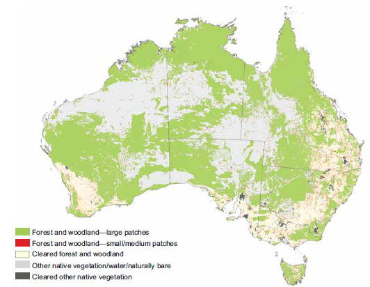
Fig. 2. Cleared areas and remnant patches of native vegetation in Australia. Source: DEWHA, 2009.

The folly of development

As funding decreases and more species become threatened, some scientists have suggested using triage to determine which threatened species to save and which to let die (Bottrill et al., 2006). However, when it comes to development, the question of which developments should be allowed has not been properly answered, with most going ahead on the assumption that impacts to the environment can mostly be avoided, minimised or offset. Developments are viewed as good by politicians in the interests of ‘progress’, jobs and economic growth.

 The Australian government’s offsets policy seeks to balance the need for development with the need to manage biodiversity. It stipulates that biodiversity offsets, which compensate for environmental impacts due to clearing, must meet a number of requirements. One of these is that offsets must “deliver an overall conservation outcome that improves or maintains the viability of the aspect of the environment that is protected by national environment law and affected by the proposed action”. However, this principle of ‘no net loss’ can only be achieved under a limited set of circumstances (Gibbons and Lindenmayer, 2007).

Yet offsets are widely applied, which has led some to assert that offsets are being used as an excuse to allow development (paragraph 1.4-1.6, Australian Greens Minority Report, in Parliament of Australia, 2014). There are many examples where offsets have not been applied appropriately and the principle of no net loss has not been achieved (paragraphs 3.68-3.77, Parliament of Australia, 2014). Some developments have also been approved on the assumption that impacts can be offset, only to find that suitable offset sites cannot be secured (paragraphs 4.27-4.29, Parliament of Australia, 2014). The result of all this must surely be a net loss of biodiversity due to land clearing. As Dr Martine Maron puts it:

“It should be made much more explicit that many impacts cannot be offset, and then the choice is between development and associated biodiversity loss, or the alternative. We cannot always have our cake and eat it, and it is misleading to imply otherwise” (paragraph 3.57, Parliament of Australia, 2014).

 Outlook for the future

 The situation is only likely to get worse in the future. There are a limited number of sites that can be used to offset development impacts (paragraph 3.94, Parliament of Australia, 2014). As development pressure increases due to predicted population growth, it is likely under the current policies that impacts cannot be offset but developments will go ahead regardless. This effectively commits us to a path of continual habitat and biodiversity loss.

Actions to address the loss of vegetation and habitat cannot compensate for the loss of vegetation and habitat in the first place. Restoration and recovery actions are costly, uncertain to succeed, and difficult to implement. We cannot protect biodiversity unless we think more strategically, drastically reduce land clearing, challenge the assumption that all development is good, and reduce population pressures. Humans rely on a healthy environment to provide goods and services such as food, freshwater, good air quality and recreation. Sustaining, instead of denuding, the environment will have many benefits for the economy and society. When it comes to a problem, prevention is always best.

References

Department of Science, Information Technology and Innovation (DSITI) (2016). Land cover change in Queensland 2014-15: Statewide Landcover and Trees Study Report. State of Queensland.

Evans, M.C., Watson, J.E.M., Fuller, R.A., Venter, O., Bennett, S.C., Marsack, P.R. and Possingham, H.P. (2011). The spatial distribution of threats to species in Australia. BioScience 61(4), 281-9.

Gibbons, P.  and Lindenmayer, D.B. (2007). Offsets for land clearing: No net loss or the tail wagging the dog? Ecological Management and Restoration 8(1), 26-31.

Parliament of Australia (2014). Environment and Communicates References Committee: Environmental Offsets. Parliament House, Canberra.

State of the Environment 2011 Committee. Australia State of the Environment 2011 (SoE 2011).
Independent report to the Australian Government Minister for Sustainability, Environment, Water, Population and Communities. Canberra: DSEWPaC.

Watson, J.E.M., Bottrill, M.C., Walsh, J.C, Joseph, L.N. and Possingham, H.P. (2011). Evaluating threatened species recovery planning in Australia. Prepared on behalf of the Department of the Environment, Water, Heritage and the Arts by the Spatial Ecology Laboratory, University of Queensland, Brisbane.


Student u3208307


Posted in Uncategorized | 2 Comments

A Real life experience from India: Walking behind the majestic tiger

Written by:Krithish Haldorai(U5914902)

With around 3900 tigers (Panthera tigris) worldwide nearly 70% of the World’s tigers reside in India. The tiger population has increased by 30 % alone in the Indian Subcontinent.

One of the most beautiful beasts in nature this species is considered as “Keystone” species in the sub – tropical forests.  Tigers are the largest cat species in the world and are classified as endangered by IUCN (International Union for Conservation of Nature). These predators can grow up to 3.3 metres (up to 11 ft.) of body length and weigh about 306 kg (675 pounds).  During the past 100 years, the magnificent beast has almost lost 90% of its natural habitat ranging from Turkey in the west to Russia in the east.

tiger-3

Image captured in Ranthambore tiger reserve (Rajasthan, India) during 2015

Why tigers are important species in the Indian ecosystem?

Tigers are the top most species on the ecosystem pyramid and their protection is the key to the life of the forest it prevails. The Reserves conserve the forest stock in the dense forests of the Indian subcontinent. The country also acquires monetary benefits from improved ecosystem services worth millions. These well-preserved forests are a natural source of carbon reduction and home to a distinct variety of flora and fauna.

Countries where Tigers can be found

Tiger population has drastically decreased in this century with many sub-species of tigers getting extinct. There are at least 10 known sub-species of tigers mainly: Bengal tiger, Indo-Chinese tiger, Sumatran tiger, Siberian tiger or Amur tiger, South China tiger and Malayan tiger. There are also four sub-species of tigers that have been completely extinct from our planet: Caspian tiger, Javan tiger, Bali tiger and Trinil (extinct during the prehistoric period).

tiger-terrirory-map-pc

      Map showing the distribution of tiger   Source: tigerhomes.org

Tigers are mainly found in countries like India, Bangladesh, Bhutan, China, Indonesia, Malaysia, Russia, Thailand, Nepal and Vietnam. The current decade has shown some positive signs for tiger population around the world with the first increase in the species has been recorded in the past 100 years. The major contribution to this change has been from India.

 My experience with the Beast

The dream of every nature enthusiast from the sub-continent region is to spot the tiger in the wild. I was fortunate to experience the nerve-wracking moment which happened earlier this year during my visit to the Mukurthi National park (11°16′N, 76°28.5′E) located 40 km from my hometown Ooty. The National park at an elevation from 1100 to 2600 metres is known for its shola forests along with its montane shrublands and grasslands.

1

The view of Mukurthi Peak taken from the National park – January 2016

We managed to get permission to enter the well-preserved park which also is home to the Nilgiri Tahr (goat- like species) which is another endangered species thriving in these forests. We were a group of 3 friends who wanted to explore some of Nature’s beauty but at that moment we were not aware that this experience would become one of the best moments in our lives.

The two-day visit to the park started with a 30 km bumpy ride through thick mountainous forests which could be covered only by the special forest Jeep. We stayed in a fishing hut almost near the heart of the Mukurthi National Park. With a well-packed lunch and a cool evening by the stream, we could not have expected for a more relaxing day.

2

The view of the stream in Mukurthi National Park

One important feature of this place was it isolated from the modern world. With no electricity and mobile phone coverage this place gave us a unique feeling. We were excited by the forest surrounding and started on an early morning walk just before sunrise.

We had just walked a few hundred metres from the fishing hut when we noticed a herd of Blackbucks. We walked forward when we first realised a strong scent of predator urine in our path, generally tigers mark their territory with urine and anal gland secretions. We continued forward with great caution stopping at curves listening to the sounds in the forests. The forest around us started getting denser and the thick overstorey made the forest dark even with the sunlight above us.

3

The path during our early morning walk- January 2016

We followed the path to reach a small creek where we found fresh pugmarks of the predator. With our hearts beating at full speed we were unsure to proceed any further. Generally, there are three signs to predators in the wild: pugmarks, Scent of urine and fresh nail marks on trees.

We stood by the creek analysing the pug marks when we heard a tiger roar maybe a few hundred metres ahead of us. With our hearts pounding hard we moved to a higher ground where we listened to the continuous roar of the predator. Unable to see our path ahead of us in the thick forest we decided to return back and left the tiger undisturbed. I am sure we were very close to having a glimpse of the majestic beast but the experience also made me realise that the path belonged to the tiger and that we were in its territory.

Successful tiger Conservation in India

The main project that was initiated to save the tiger population was called the ‘Project Tiger’ which was started in 1973 by the Indian government. In order to protect the national animal, the tiger task force was initiated by the National Tiger Conservation Authority in 2005.

bigcatcomback

Graph showing the tiger population growth due to conservation measures

Currently, there are 47 exclusive tiger reserves in India and the Government has also planned to add another 10 reserves in the near future. With modern methods like camera trapping, images captured using drones the results have now become more credible.

tiger-cub-2

Image captured in Ranthambore tiger reserve (Rajasthan, India) during 2015

Many of the tiger reserves have been instrumental in setting up the ‘Eco-sensitive zone’, It is a 10 km zone from the reserve where no mining, Industries and hotels can be set up. Many tiger countries are set to adapt the Indian methodology to conserve tigers. Experts and scientist in India consider that tiger population indicates the health of forest apex in the country. The positive conservation measures have been welcomed by the scientific community throughout the world. It is, therefore, crucial to ‘ walk behind the tiger’ and implement conservation measures for other endangered species.

Acknowledgments

I would like to thank the Nilgiri Wildlife Association for granting us permission to visit the park.

My friend/Wildlife photographer Prajwal Rajappa for providing the pictures of the tigers.

References

KARANTH, K. U., NICHOLS, J. D., SEIDENSTRICKER, J., DINERSTEIN, E., SMITH, J. L. D., MCDOUGAL, C., JOHNSINGH, A., CHUNDAWAT, R. S. & THAPAR, V. 2003. Science deficiency in conservation practice: the monitoring of tiger populations in India. Animal Conservation, 6, 141-146.

O’BRIEN, T. G., KINNAIRD, M. F. & WIBISONO, H. T. 2003. Crouching tigers, hidden prey: Sumatran tiger and prey populations in a tropical forest landscape. Animal Conservation, 6, 131-139.

SANDERSON, E. W., FORREST, J., LOUCKS, C., GINSBERG, J., DINERSTEIN, E., SEIDENSTICKER, J., LEIMGRUBER, P., SONGER, M., HEYDLAUFF, A. & O’BRIEN, T. 2010. Setting priorities for tiger conservation: 2005–2015. Tigers of the world: the science, politics, and conservation of Panthera tigris. Boston: William Andrew Publishing, 143-161.

SEIDENSTICKER, J. 1999. Riding the tiger: tiger conservation in human-dominated landscapes, Cambridge University Press.

SUNQUIST, M., KARANTH, K. U. & SUNQUIST, F. 1999. Ecology, behaviour and resilience of the tiger and its conservation needs. Riding the tiger: tiger conservation in human-dominated landscapes, 5-18.


Posted in biodiversity conservation | 2 Comments

Volunteering for Frogwatch was an Unfrogettable Experience

e13bcd815090c90373124c1b22c9a1038b68059952541f2c25d1f305d94f587b_1 Figure 1. A frog doing what it excels best in: Being cute

Frogs are super cute and harmless to humans (Fig 1.), but globally, they are in serious decline due to threats like pollution, introduced fish species, loss of frog habitat, and disease (Fig 2).

vbeycfmbFigure 2. How I feel about the loss of frogs

How do we stop frogs from disappearing? One strategy to mitigate the loss of biodiversity is monitoring. This is what The ACT and Region Frogwatch program (Frogwatch for short) is all about!

What is Frogwatch?

Frogwatch is a program that involves a large number of volunteers from all ages to conduct monitoring of frogs. The data submitted by volunteers is used for providing valuable information about frog populations in the ACT and region.

But why frogs?

Frogs are an indicator species. What this means is having them around can tell you stuff about the environment. For frogs, they are an indicator of environment health, and their presence can indicate if a habitat is of high quality with good quality water.

They are also useful to monitor because:

  • Frog eggs do not have a shell, and adult frogs have a permeable skin to “drink” and breathe through. Therefore, frogs are sensitive to even small concentrations of pollutants such as pesticides, detergents and industrial chemicals.
  • Frogs require water to breed. Therefore, frogs can only reproduce in waterways that are relatively free of toxic pollutants.
  • Each frog species has a distinctive mating call which is easy to learn and recognise. Therefore frogs can be monitored in a non-invasive, inexpensive way.

ar7swjtFigure 3. This picture is  just here to keep your attention.

So what does Frogwatch do?

Frogwatch has two main goals:

  1. Organising and maintaining an annual community frog-monitoring program.
  2. Delivering a range of school education products to help students learn about frogs.

I helped out with both of these goals, but I mainly helped out with goal two.

What did I do?

I went through the training seminar on how to do a frog survey. I conducted my own survey of a dam near my house. I plan on doing more surveys in the future because in science, the more data scientists have, the better the analysis will be. You can hear me conducting a survey here: http://fw.ginninderralandcare.org.au/surveys/dgp001/2016-10-09

What I mainly did was help out with goal two, which was Frogwatch’s Tadpole Kit Program (Fig 4).

f3dc871b68d88f82e0df6c38bc9e473c Figure 4. Tadpole pun.  

People want to move frogs for various reasons. However, removing and displacing tadpoles and frogs from the wild without a specific license is illegal in the ACT (Fig. 5).

dcf414153cbc37f4e54fe81a5205e31fFigure 5. Don’t move frogs around, it’s illegal!

Frogwatch wants to educate people about moving frogs but still give an opportunity for people to have a look at frogs. So Frogwatch loans out complete Tadpole kits so that students can observe the amazing process of tadpoles going through metamorphoses (Fig 6).

58dc364c9f3191f1f3b6b3500efe6ac4Fig 6. This is what I think of when I hear the word metamorphoses. Note that this is not what metamorphoses is!

Over the two days I had to assemble about 100 tadpole kits (Fig. 7 & 8) Contents included a tank, information booklets, gravel, scrub, frog food, a water treatment bottle, a bucket, and of course tadpoles.

img_20161010_105625002Figure 7. What came in the Tadpole kit.

img_20161010_123210340Figure 8. Me catching tadpoles. You can see a tadpole up in the left hand corner.

Making the kits wasn’t too bad but getting the tadpoles was very time-consuming! Just imagine trying to catch eight small and camouflaged tadpoles swimming around in a big container of water… now imagine doing that 100 times! (Fig 9.)

201603_1131_bfdcb_smFigure 9. Me being frustrated trying to catch the tadpoles


Then we had to deliver these kits to teachers from different schools. The first day of delivery was crazy because you have a swarm of north side teachers who were keen to get their hands on tadpole kits.

Day two was much worse because we had to transport these kits to the south side. Anke-Maria who is the frog coordinator of Frogwatch, had a sick child and had to go home which left me to do most of the work.

I had to fit in tons of tadpole kits in my car and catch about 50×8 tadpoles again. My car was so full of boxes, gravel, and tadpoles (I wish I got take a picture of this because it was packed!).

Turns out I misheard Anke-Maria and made way more tadpole bags then I needed, and because tadpole catching is time-consuming, and because I didn’t know what time I had to be down at south side, I ended up being late by 40 minutes (Fig 10).

1c7vvrxFigure 10. Me when receiving instructions.

Luckily for me, Anke-Maria came down to South Side for the rescue. And despite the rough start, everything turned out good in the end (Fig. 11).

feels-good-manFigure 11. How I felt after the hardships of volunteering

What did I learn?

I learnt how small the Frogwatch organisation was. Anke-Maria is basically the only person behind Frogwatch. Besides the tadpole kit program, she also conducts seminars on frog watching, she listens in to the frog recordings people send in (which I linked earlier) to verify if people have correctly identified the frogs, she does all the administration work, and top that off with being a mother.

What you can do

I can’t imagine how things would have gone for her if I didn’t offer to volunteer. Having other volunteers would have made both our lives easier in this hectic time. Anke-Maria also said that she’s always looking for volunteers because it would free her up to do other project ideas for Frogwatch.

To volunteer send an email to: Frogwatch(at)ginninderralandcare.org.au

Got any questions about what I did at Frogwatch? Comment below! Or send me an email scabe3000(at)hotmail.com

P.S. I got to take home my own tadpole kit. Can’t wait to see them grow up! (I know it looks like nothing right now but that blob right there is a tadpole tank!)

img_20161012_210952523

My volunteering experience occurred on  9 October – 12 October 2016.
Written by Satra Kien
u4688216

Resources

Learn about how to create a habitat for frogs at the Frogwatch site: http://www.ginninderralandcare.org.au/frogwatch

Find out about frog threats and other information about Frogs http://www.environment.nsw.gov.au/animals/ThreatsToFrogs.htm

Learn more about Frogwatch: http://www.ginninderralandcare.org.au/sites/default/files/imported/res/File/PDFs/Frogwatch%20Kit/2008%20Frogwatch%20Kit/Frogwatch%20Census%20Kit%202008_PDF.pdf

Posted in biodiversity conservation, Volunteer work | 2 Comments

Things are heating up: invasive grassy weeds and climate change in Canberra

What is a weed?

As described in the Australian Capital Territory (ACT) Weeds Strategy, a weed is ‘considered to be a terrestrial or aquatic species of non-native or native plant that is harmful to the natural environment (ecosystems/biodiversity), agriculture and other industries, or public amenity and health’ (Department of Environment, Climate Change, Energy and Water, 2009).

For the purpose of biodiversity conservation in Canberra’s reserves, this means that both native and non-native species can be considered weeds if they are not endemic to the area. Even non-local natives could pose a threat to biodiversity by competing with local native shrubs, small trees and ground flora, and impede their regeneration.

Prioritising weeds

The Australian Government maintain a Weeds of National Significance (WoNS) list which details priority weeds identified as having the potential for spread causing environmental, social and economic impacts. Currently there are thirty two weeds on the WoNS list, of which the following two grassy weeds have been found in the ACT:

  • Chilean Needle Grass (Nassella neesiana)
  • Serrated Tussock (Nassella trichotoma)

The ACT has its own legislation regarding pest plants and animals (Pest Plants and Animals Act 2005) and also a separate weed strategy which details 77 plants declared as environmental weeds in the ACT, including two additional grassy weeds:

  • African Love Grass (Eragrostis curvula)
  • Mexican Feather Grass (Nassella tenuissima)

Serrated tussock

Serrated tussock is widely established in the ACT although it is not a local, it is native to South America. It reaches from the southernmost border in Namadgi National Park to the norther border of the ACT. Surrounding land in NSW is also extensively effected.

Serrated tussock infestation on Mt Majura, Canberra (Photo: Canberra Nature Map)

Serrated tussock infestation on Mt Majura, Canberra (Photo: Canberra Nature Map)

It is a perennial C3 tussock-forming grass with a deep fibrous root system making it very difficult to pull from the ground. Mature plants can produce more than 140 000 seeds per plant per year. The seeds are easily carried by the wind, and even after treatment the seed bank in the soil typically requires substantial follow-up treatment. Serrated tussock is also highly unpalatable to both livestock and native mammals (Department of the Environment and Energy (1), 2016).

 African lovegrass

African lovegrass has spread throughout Canberra, though it is not a local either. African lovegrass originated from southern Africa. It is a highly persistent summer growing (C4), perennial grassy weed which can tolerate sandy soils with low fertility. Seeds are easily spread animals, mowers, vehicles, water and wind. ‘Spread is enhanced by drought conditions and over-grazing. Paddocks with low ground cover are more susceptible to invasion’ (NSW Department of Primary Industries, 2015).

alg-bonner

African lovegrass infestation in the suburb of Bonner, Canberra. (Photo: Canberra Nature Map)

Due to its lightweight structure, African lovegrass is highly flammable and poses a high fire risk in areas of dense infestation. The weed however, is not killed by fire and therefore post-fire treatment is always required to stop re-establishment.

lovegrass-fire-sign

Signs warning of the fire danger from African lovegrass line the Monaro Hwy, close to Canberra. (Photo: James Bennett)

Chilean needle grass

Chilean needle grass is a perennial tussock grass native to South America. It grows in dense clumps and is closely related to serrated tussock. The grass has a persistent seedbank which can survive even after the adult plants are killed and has the potential to produce more than 20,000 seeds per square metre. Chilean needle grass requires bare earth to seed and therefore good ground cover can reduce infestations. It is heavily grazed by Macropus giganteus (Eastern grey kangaroo), making it harder to identify. In areas where grazing is high, this can make spread of the invasive weed easier (Department of the Environment and Energy (2), 2016).

cng-1

Needle-like hairs on Chilean needle grass (Photo: Canberra Nature Map)

cng-2

Chilean needle grass infestation (Photo: Lowan Turton)

Disturbance factors

There are a number of disturbance factors including land management practices and climate change which effect a weeds ability to become invasive. Land clearing, intensive agriculture and fire are examples of land management practices which can alter the ecosystem structures and allow for invasive weeds to take hold (Department of the Environment and Energy (3), 2016).

  • Wild fire or prescribed fire which causes significant reduction in the canopy allows more sunlight to reach the ground and gives weeds a chance to thrive.
  • Land clearing and agricultural practices using fertilisers can provide certain weeds an opportunity to out compete native pastures.
  • Climate change can cause flooding which spreads weeds. Droughts may also weaken native plants and allow adaptable weeds to invade.
darling-pea-after-fire

Native legume Darling pea (Swainsona greyana) thriving like a weed after bush fire (Photo: Louise Knight)

Climate change and grassy weeds

The latest climate modelling undertaken by CSIRO indicated a high confidence that southern and eastern Australia are projected to experience harsher fire weather. ‘There is very high confidence in continued increases of mean, daily minimum and daily maximum temperatures throughout this century for all regions in Australia’ (CSIRO and Bureau of Meteorology, 2015, p. 8).

This might mean good news for invasive grassy weeds which can tolerate warmer and drier conditions and/or larger variations in climate. However, this may mean bad news for land managers. With climate change comes predicted increases in temperature and also elevated atmospheric CO2. CO2 is known to improve the growth of plants due to increased efficiency in photosynthesis.

Most plants are known as C3 which means they form a three-carbon compound during photosynthesis, however some grasses have now been found to be C4, meaning they form a four- carbon compound during photosynthesis. Generally, C4 grass species originate from warmer climates than C3 species (Scott, et al., 2014, p. 18).

Modelling of weeds of national significance suggests:

‘Chilean needle grass is expected to increase its range because it is highly invasive (longlived, seed dispersed by wind and water) and drought tolerant.

Serrated tussock is expected to retreat southwards and to higher altitudes because it is sensitive to higher temperatures. As a drought-tolerant plant, it should become more invasive in areas where temperature allows’ (Meat & Livestock Australia, 2008, p. 4).

As years progress and the effects of climate change are felt, it will be interesting to see both native and non-native invasive response to increasing temperatures and CO2. With an understanding and appreciation of grassy weed potential responses to climate change, land managers can strategically plan for the future.

Student U4009852

References

CSIRO and Bureau of Meteorology, 2015. Climate Change in Australia Information for Australia’s Natural Resource Management Regions: Technical Report, Australia: CSIRO.

Department of Environment, Climate Change, Energy and Water, 2009. ACT WEEDS STRATEGY 2009 – 2019, Canberra: Department of Environment, Climate Change, Energy and Water.

Department of the Environemnt and Energy (1), 2016. Nassella trichotoma. [Online]
Available at: http://www.environment.gov.au/cgi-bin/biodiversity/invasive/weeds/weeddetails.pl?taxon_id=18884

Department of the Environment and Energy (2), 2016. Nassella neesiana. [Online]
Available at: http://www.environment.gov.au/cgi-bin/biodiversity/invasive/weeds/weeddetails.pl?taxon_id=67699

Department of the Environment and Energy (3), 2016. Factors influencing weeds. [Online] Available at: http://www.environment.gov.au/biodiversity/invasive/weeds/weeds/why/factors.html

Meat & Livestock Australia, 2008. Communicating Climate Change: Climate change impacts on pest animals and weeds. s.l., s.n.

NSW Department of Primary Industries, 2015. African lovegrass (Eragrostis curvula). [Online] Available at: http://weeds.dpi.nsw.gov.au/Weeds/Details/3

Scott, J. et al., 2014. Weeds and climate change: supporting weed, Canberra: AdaptNRM (CSIRO).

Posted in biodiversity conservation, Climate change | Tagged , , , , , | 1 Comment

A “zombie” relationship in tropical rainforest, West Kalimantan, Indonesia

A Story

Some of the action horror films that used “zombie” theme had been recorded as “Box office” or popular categories. Maggie (2015), Shaun of the dead (2004), Dawn of the dead (2004), you listed. Do you think zombie really exist or it is only science fiction? I have a story!

It was September 2009, after seven up to nine hours walking through a pristine forest, I found a unique creature. It is a dead ant that bites the vain of the leaf with some fruiting bodies of fungus on its body. What a frightening thing. I do not give much attention because I have to conduct Orangutan (Pongo pygmaeus wurmbii) nest count project for next four of five days. Luckily, one of my colleges took a photo of this ant.

Fig 1. Dead ant with fungus at Gunung Palung National Park, West Kalimantan, Indonesia (Credit to Endro Setiawan)

Fig 1. Dead ant with fungus at Gunung Palung National Park, West Kalimantan, Indonesia (Credit to Endro Setiawan)

Fig 2. Another photo by tourist at Gunung Palung National Park (Credit to Rajesh mohanasundaram)

Fig 2. Another photo by tourist at Gunung Palung National Park (Credit to Rajesh mohanasundaram)

Fig 3. Gunung Palung National Park, West Kalimantan, Indonesia

Fig 3. Gunung Palung National Park, West Kalimantan, Indonesia

When I run another project in the different location at the same park several months later, I find dead ant with similar condition but concentrated in a large number, like a graveyard. I have not counted it, but I am pretty sure it should be hundreds of ants or more. I also found this creature in several locations in my experience work as ecosystems controller in Gunung Palung National Park, West Kalimantan, Indonesia. My attention grew up because these ant died in the similar condition. They are same species, bite on or under main vein of the leaves, face their head to the same direction, less than 50 cm from ground and similar fungus grew from their head and body. This is very precise location. Who can do this or are that ants “inherent” such way of death from their ancestors?  I started to ask some researcher and do a little bit online research. Finally, I found that this is not a novel, Alfred Russell Wallace in 1859 found this features in his travelling notes from Sulawesi, Indonesia (Hughes et al., 2011).This is an ant species that was hijacked by the specific fungus to do its favor.

The fungus is Ophiocordyceps sp, known as zombie fungus or just call Cordyceps while the ant comes from the genus of carpenter ant (Camponotus sp). Several studies, mostly in Thailand and Brazil have been done to understanding this process, such as by Hughes et al. (2011), Evans et al. (2011) and (Andersen and Hughes, 2012).

Fig 4. Undisturbed forest in the park that seems suitable for zombie process

Fig 4. Undisturbed forest in the park that seems suitable for zombie process

Brain-manipulating actor

Harmon (2009) briefly described these process as:

You are a fungus that can only flourish at a certain temperature, humidity, location and distance from the ground but can’t do the legwork to find that perfect spot yourself. Solution: hijack an ant’s body to do the work for you—and then inhabit it.

However, carpenter ant is a canopy-dwelling species and travel in the forest floor in the certain trail within 3-5 meters of their nest in the tree (Hughes et al., 2011). So how to make this ant goes down and bite the leaf that approximately 25 cm above the ground? In Thailand, Andersen and Hughes (2012) found it is 25.20 ± 2.46 SE cm, while Hughes et al. (2011) found ca. 25 cm above the ground. Well, this is why cordyceps fungi “control the behaviour of the host before killing it” (Evans et al., 2011). Another name of this fungi is the brain-manipulating fungus.

The process

 I am not good in the summary process, especially for this complicated tiny manipulating process. However, this is what I found from several scientific papers. The process started with sporulation phase when microscopic spores that dropped from a fungus fruiting body, land on the ant which were walking on the floor of the rainforest. Next, the spores are breaking the ant exoskeleton using mechanical pressure and enzymes. After that, yeast spread in the body and produce compounds that controlled ant’s brain. After two days, like a zombie, the ant is driven from canopy to the precise location for a fungus to grow. The order is clear: behind the leaf and roughly 25 Cm above the ground.

The next order is to make “lock-Jawed” position or “death-grip” by bites the vain of the leaf with their mandible to secure the body along the process. Once set in, fungus damage the connection in the muscle fiber that controlled the mandible. At the final stage, fungus killed the ant and growing hyphae and mycelia. When fungus ready to reproduce, they producing fruiting bodies from ants head and releasing spores, creating 10 square feet killing zone for other ants.

Fig 5. Resume of zombie ant process based on several references

Fig 5. Resume of zombie ant process based on several references

Is it important for biodiversity conservation?

In ENVS3039/6024 class, we had learned that biodiversity divided at 3 level which are genes, species, and ecosystem. In this interaction, we can understand several items. Firstly, we got a new knowledge about carpenter ants (Componotus sp) and also zombie fungi (Ophiocordyceps sp). It is urgent to understanding tropical systems since tropical rainforest are fast disappearing (Evans et al., 2011). Secondly, we understanding that this fungus could balance the ant population which sometimes could be eight million individual on a single ha (https://www.youtube.com/watch?v=XuKjBIBBAL8).

Since the fungi only found on certain condition it also could be used as the indicator of the disturbance in the tropical rain forest. I never found this relationship at logged area in Gunung Palung National Park. This relationship has a potential value in chemistry or medicine. For instance, Tibet’s golden “worm” or caterpillar fungus is famous as expensive medicines to alleviate back pain, impotence, jaundice, fatigue up to tuberculosis, hepatitis and anemia (National geographic). This is the result of zombie process between Ophiocordyceps sinensis and moth (Thitarodes sp). However, extensive research is needed.

Fig 6. Zombie process in Tibet’s golden worm (Microbe Wiki).

Fig 6. Zombie process in Tibet’s golden worm (Microbe Wiki).

So based on the story above, the zombie interaction exist in the tropical forest. In term of biodiversity, we should look the interaction between species within ecosystem scale.

That’s all from me. Thanks for reading

Ibrahim Sumardi/ U6130746

References

ANDERSEN, S. & HUGHES, D. A. 2012. Host specificity of parasite manipulation. Communicative & Integrative Biology, 5, 163-165.

EVANS, H. C., ELLIOT, S. L. & HUGHES, D. P. 2011. Ophiocordyceps unilateralis: A keystone species for unraveling ecosystem functioning and biodiversity of fungi in tropical forests? Communicative & Integrative Biology, 4, 598-602.

HARMON, K. 2009. Fungus Makes Zombie Ants Do All the Work. The Scientific American, 31.

HUGHES, D. P., ANDERSEN, S. B., HYWEL-JONES, N. L., HIMAMAN, W., BILLEN, J. & BOOMSMA, J. J. 2011. Behavioral mechanisms and morphological symptoms of zombie ants dying from fungal infection. BMC Ecology, 11, 13.

http://www.photomacrography.net/forum/viewtopic.php?t=22174&sid=4155a9b4c6a917a1c5458ede633cd770

http://ngm.nationalgeographic.com/2012/08/tibetan-mushroom/finkel-text

Posted in Introduction to ecology | 3 Comments

For country and conservation: Indigenous culture and biodiversity in jointly-managed National Parks

The view of Gulaga Mountain from the Najanuga Outcrop.

The view of Gulaga Mountain from the Najanuga Outcrop. Image: Sam Provost.

Recently I had the honour of accompanying Paul Brown, a Yuin man and NSW National Parks and Wildlife Service Ranger, for two days in Gulaga and Biamanga National Parks on the south-east coast of NSW.

The NSW National Parks and Wildlife Service office in Narooma, NSW.

The NSW National Parks and Wildlife Service office in Narooma, NSW. Image: Sam Provost.

During this time, Paul and I explored the Parks, and I learned a lot about how they are managed both for cultural and biodiversity conservation.

The management of Gulaga and Biamanga National Parks is carried out in a way that is unique to this area. This is because the Parks have been handed back to the Traditional Owners who manage the landscape with the Office of Environment and Heritage and the NSW National Parks and Wildlife Service.

To understand how the Parks are managed and how management decisions affect the rich biodiversity in these areas, I had to learn the history of the mountains and how stakeholder’s perceptions have changed over time.

Sacred places: conflict and reconciliation

fullsizerender-3

Image: Sam Provost.

The Gulaga and Biamanga Mountains are sacred to Aboriginal people of the Yuin Nation. According to lore, Biamanga is a men’s mountain, a place where ceremony and initiations take place for men and boys. In the same way Gulaga Mountain, the mother mountain, is a sacred place for women. The protection and management of these sites and everything within them is key to the continuing culture of the Yuin Nation.

Areas within the Parks were logged as state forests in the 1970’s, sparking protests from local aboriginal people. These protests, led by elder Guboo Ted Thomas, raised awareness about the importance of Gulaga and Biamanga for Yuin people.

‘Why we are interested in this land is that they are sacred sites, they are part of us,’ said Guboo Ted Thomas when lobbying to halt logging operations on Biamanga mountain.

Yuin elder, Guboo Ted Thomas. Image: Sydney Morning Herald.

Yuin elder, Guboo Ted Thomas. Image: Sydney Morning Herald.

‘You have your cathedrals in Sydney where you worship. It is the same for Aboriginal people. We do not want to lose our culture. We are trying to restore all our sacred sites. We want to retain where we worship’ (Fox, 2002).

After years of lobbying, logging in Biamanga ceased, and in 1980 the area was protected as an Aboriginal Place. Biamanga and Gulaga were gazetted as national parks in 1994 and 2001, respectively (NSW National Parks and Wildlife Service, 2014).

In 2006, Minister for Environment Mr Bob Debus handed back Gulaga and Biamanga National Parks to their Traditional Owners, making them the first National Parks to be returned to Aboriginal ownership on the eastern seaboard (NSW National Parks and Wildlife Service, 2014).

‘For as far back as the mind can reach, the Yuin people possessed and worshipped these mountains, these creeks and trees,’ Mr Debus said at the hand-back ceremony.

‘Long before Babylon was built, or the great pyramid, Gulaga and Biamanga had their present names, and people related to people here this morning saw them as heartland, as mother, as blessed home, and gave them reverence.’

Stakeholders: culture, conservation and recreation

The Parks are managed by the Gulaga Biamanga Board of Management. The Board has an Indigenous majority, with non-Indigenous members including the Regional Manager of NPWS, an elected councillor of the Eurobodalla Shire Council, local citizens concerned with the conservation of the area, and a representative for landowners adjacent to the Parks.

Unlike most of Australia’s National Parks, which focus on biodiversity conservation first and cultural conservation second (Parks Australia, 2016), Gulaga and Biamanga National Parks have a commitment to the conservation of local Aboriginal cultural above the conservation of biodiversity (NSW National Parks and Wildlife Service, 2014).

As Paul Brown says, the Parks are ‘guided by, but not bound by NPWS nature conservation policies’.

However, this does not mean that conservation falls by the wayside. The Board argue that cultural and biodiversity conservation are inexorably linked because Aboriginal culture is built on valuing every aspect of the landscape.

This concept has been put forward in many papers discussing the interconnectedness of Aboriginal cultural connections with the natural world (Morrison and Carmody, 1996; Altman and Whitehead, 2003; Pascoe, 2014; Gammage, 2011; Sveiby, 2009).

Biodiversity and management

This creek is a sacred area in Biamanga National Park, but it is also habitat for the endangered green and golden bell frog.

This creek is a sacred area in Biamanga National Park, but it is also habitat for the endangered green and golden bell frog. Image: Sam Provost.

Gulaga and Biamanga National Parks play host to an extensive range of animal and plant biodiversity (NSW National Parks and Wildlife Service, 2014). There are 11 mammal species classified as endangered under the Threatened Species Conservation Act 1995 including the southern brown bandicoot (Isoodon obesulus obesulus), green and golden bell frog (Litoria aurea) and swift parrot (Lathamus discolour); a further 43 species are listed as vulnerable including koala (Phascolarctos cinereus) and powerful owl (Ninox strenua).

Biodiversity in the park is managed and conserved through on-the-ground surveys, data collection and data analysis which inform decisions made by the Board of Management and NSW NPWS.

Critical processes for conserving biodiversity are pest control, public awareness programs, and strategic fire management.

Fire in the landscape

Two large, intense bushfires in Biamanga, one in 1972 and another in 1980 had devastating effects on small mammal communities (Lunney et al., 1987) including EPBA listed eastern pygmy possum (Cercartetus nanus), the native bush rat (Rattus fuscipes), the swamp rat (Rattus lutreolus), and the latter completely wiping out the population of dusky antechinus (Antechinus swainsonii) (Recher et al., 2009). In 2009, 3,480 hectares of the Parks were burnt due to an escaped fuel reduction burn (NSW National Parks and Wildlife Service, 2014).

A bushfire threatens the small village of Central Tilba, NSW, Australia on September 9th 2009. The fire reached within 50 metres of the village but was spared by firefighters and rain a short time after thie photo was taken

Gulaga Mountain burning during the 2009 fires. Image: John Lindsay Small.

Fire has historically been an integral part of the environment and was used by the Yuin Nation for many reasons including to ‘clean up’ areas (fuel load reduction) and for ceremonial purposes (ibid, 2014).

Modern fire management strategies in the Parks mainly focus on strategic fuel reduction to mitigate the threat of wildfire and to preserve the habitat of key species, especially koala populations who are extremely vulnerable to fire.

The Gulaga Biamanga Board of Management and the NSW National Parks and Wildlife Service are interested reintroducing traditional Aboriginal burning practices in the parks for cultural and biodiversity conservation (ibid, 2014) and will begin trails in winter 2017 (Personal correspondence, 2016).

Looking forward, looking back

Improving and maintaining biodiversity values in Gulaga and Biamanga National Parks is vital for ensuring the continued provision of the ecosystem services this beautiful country provides. Aboriginal culture sits at the heart of this, with sustainable land management practices shaping this landscape. The move to include Yuin values in the management of these parks is more than respecting the Traditional Owners – it is an acknowledgement that best practice must be built around the thousands of years of local knowledge and connection to the landscape.

Sam Provost

References

Altman, J. and Whitehead, P., 2003. Caring for country and sustainable Indigenous development: Opportunities, constraints and innovation, Centre For Aboriginal Economic Policy Research. Available at: http://www.anu.edu.au/caepr/

Fox, T., 2002. Guboo Ted Thomas: 1909-2002, Australian Aboriginal Studies, 2002(2): 120-122.

Gammage, B., 2011. The Biggest Estate on Earth: How Aborigines Made Australia, Allen & Unwin, Crows Nest.

Lunney, D., Eby, P. and Cullis, B., 1987. Effects of logging and fire on small mammals in Mumbulla State Forest, near Bega, New South Wales, Australian Wildlife Research, 14, 163-81.

Morrison, J. and Carmody, M., 1996. Working Within The Framework Of Aboriginal Culture: Indigenous Initiatives For Sustainable Development Through Landcare, International Permaculture Conference and Convergence.

NSW National Parks and Wildlife Service, 2014. Plan of Management, Yuin Bangguri (Mountain) Parks, NSW Government.

National Parks, 2016. About Us. Available at: https://www.nationalparks.nsw.gov.au/.

Pascoe, B., 2014. Dark emu – black seeds: agriculture or accident?, Magabala Books, Broome, Western Australia.

Recher, H. F., Lunney, D. and Matthews, A., 2009. Small mammal populations in a eucalypt forest affected by fire and drought. I. Long-term patterns in an era of climate change, Wildlife Research, 36(2): 143.

Sveiby, K. E., 2009. Aboriginal principles for sustainable development as told in traditional law stories, Sustainable development.

Posted in Uncategorized | 2 Comments

Farming: biodiversity’s biggest enemy, and its greatest ally


Figure 1: agriculture is associated with land clearing, but we can change that!

Figure 1: agriculture is associated with land clearing, but we can change that!

Global biodiversity is under siege faster today than at any time in Earth’s history. As we rush to expand our farms and feed 9 billion people by 2050, we’re pushing Earth’s planetary boundaries to dangerous levels well beyond their sustainable limits.

Covering nearly 1/3 of Earth’s surface, agriculture feeds 90% of the world’s population on just 15 plant species and 8 animal species, and is Australia’s single biggest contributor to habitat loss.

Biodiversity be damned.

Yet, despite this, modern agriculture is now the key to biodiversity conservation.


How could farming possibly be good for biodiversity after all that!?

I’ll admit, those stats above look rather bleak. But, hear me out here!

Let’s start by looking at why agriculture is so bad for biodiversity.

Agriculture needs a lot of land, so people clear a lot of land to grow their crops and feed animals.

However, doing this causes has a disproportionately negative affect on biodiversity. Let’s look at why that is in Figure 2. In a relatively intact environment, some habitat loss makes minimal difference to the rate of species loss. But, if we look at the species loss between (a) and (b) in Figure 2, habitat loss progressively accelerates the rate of species loss disproportionately at <30% of remaining habitat area. This holds true for pretty much all scales: over several kilometres, or just a few hundred.

This is because, as Andren explains, when remaining habitat drops to 30-40%, biodiversity becomes increasingly affected by declining patch size and increasing isolation.

Figure 2: notice the accelerating rate of species loss between (a) and (b)

Figure 2: notice the accelerating rate of species loss between (a) and (b)


So, how can farmers help?

Agriculture and farmers can help address two major components of habitat loss: cumulative habitat, and habitat connectivity.

Whereas cumulative habitat refers to the total amount of habitat in a given range, habitat connectivity refers to how easily species can move between two patches of habitat. For example, if a patch is too isolated for species to move into, then it is not interconnected and therefore does not contribute to the cumulative habitat.

This is where farmers and agriculture comes in.

By creating patches of habitat on owners’ farms, they can create what is known as a “nature corridor,” which can essentially create a stepping stone between two isolated habitats.

Benefitting many invertebrates and terrestrial animals as well as birds, building these patches of habitat offers agriculture a way of contributing greatly to conservation.

This principle is demonstrated in figure 3.

Figure 3: farms can improve biodiversity by serving as a stepping stone

Figure 3: farms can improve biodiversity by serving as a stepping stone

Therefore, by creating even small patches of habitat on your farm, you can markedly contribute to biodiversity conservation. What’s more, you can both receive a grant from the government to assist with this, and reap associated financial benefits for your farm in the form of improved productivity.

Putting theory to practice

To demonstrate these principles in action, I returned to my family farm to undertake rehabilitation from the 7th to the 10th of September (2016).

Located in Largs, NSW, opposite the oldest continually running primary school in Australia, this site has been used for agriculture for about 175 years. The farm was originally used to grow vegetables before transitioning to a dairy farm during the 1900’s and today an organic hobby farm producing chickens, sheep, pigs, and up to 20 head of cattle.

So, it’s fair to say the land has had a long history of land clearing and habitat loss.

To address this, I focused my rehabilitation efforts on the areas marked in blue in figure 4. This was area was chosen because it represents a wetland and significant hill which may erode into the wetland. If this occurs, significant aquatic habitat could be lost. Therefore, to protect the wetland, the hill also needs to be rehabilitated.

Figure 4: my family farm in Largs, NSW.

Figure 4: my family farm in Largs, NSW.

Focusing on the areas market in blue, I aimed to rehabilitate habitat by planting a lower, mid, and upper storey of native species. This was done because it creates a balanced ecosystem which can be of use to both large and small animals (our free range chickens will love scratching around in the understorey!).

To recreate the habitat, I focused on planting a mixture of species native to the Lower Hunter and in particular wetland areas. For the lower storey, I focused on planting sedges and rushes as these plants work well in wetland areas and are excellent habitat for small aquatic birds like the Water Hen (Gallinula chloropus).

Rehabilitation can also have great side benefits for farm resources as well. For example, the strategic planting of rushes helps discourage cows from coming too close to the banks of the dam and eroding its edges (a costly exercise to repair).

To recreate the mid storey on the hillside, I focused on planting native species such as Tea Trees (Melaleuca alternifolia) and Bottle Brushes (Callistemon), amongst others. Creation of this layer was done to encourage native bees and birds with the flowers of these trees. This is crucial to improving pollination in the region.

The upper storey on the hillside was populated with trees like the Blue Gum (Eucalyptus globulus) and Turpentine (Syncarpia glomulifera). To add to farm resources, I also added White Mahogany (Eucalyptus acmenoids) because it makes excellent timber for making fence posts in the future- thereby creating farm forestry resources! Just one of the many side benefits of habitat rehabilitation.


Closing thoughts

Overall the work was very easy, with great benefits for the farm and biodiversity. Our chooks have a new scratching ground, cows have shelter in the summer, the banks of our dams are more protected, and in the future we can use the white mahogany for fence posts.

Moreover, farms are also an ideal candidate for maximum biodiversity returns on investment. This is because, as Philip Gibbons points out, rehabilitation in highly degraded sites has the greatest biodiversity returns. This concept is explained in figure 5. Investing in sites which have already been rehabilitated will always have diminishing returns. Therefore, we can be sure that we got the best bang for our buck in both farm resources and biodiversity!

Improved biodiversity, increased farm assets, happy chooks, and possibly even increased land value caused by improving eco-assets.

What’s not to love?

Figure 5: getting the best bang for your buck. Investing in previously unmanaged sites gives better biodiversity return on investment than managed sites

Figure 5: getting the best bang for your buck. Investing in previously unmanaged sites gives better biodiversity return on investment than managed sites


By Kieran Hancock (u5584329)

Posted in Uncategorized | 1 Comment

Welcome Back: the Bettongs of Mulligans Flat

mulligans_flat

Yellow box-red grassy woodland at Mulligans Flat

If you venture towards the outskirts of north-eastern Canberra, near the suburb of Forde, you may come across a true hidden gem – Mulligans Flat Nature Reserve – and you may also catch a glimpse of one of its new local residents, the Eastern Bettong.

The reserve was established in 1995, to protect one of the last remaining patches of the critically endangered ecological community, yellow box-red grassy woodland, as well as a range of its native residents. Adjacent to Mulligans Flat is the Goorooyarroo Nature Reserve, which was established in 2004 – together they represent the largest intact area of grassy woodland left in the ACT (Manning 2011).
Before European settlement, this ecological community was once widespread across much of eastern Australia. Though in the early 1800s, most of the habitat was cleared by settlers and transformed into landscape used for crop and livestock production (ACT Government 2016). Today, only 5% of the original grassy woodland habitat still stands. However, majority of these patches are highly fragmented, and much of the life that once thrived in these communities have sadly been lost, due to loss of habitat and introduced species (Manning 2011).

Species which had disappeared from this local environment include the Eastern Quoll, Eastern Bettong, Bush-Stone Curlew, and the New Holland Mouse – some which had completely been wiped off the Australian mainland. In 2006, the ACT Government in a research partnership with ANU and CSIRO, announced their plan to build a sanctuary at Mulligans Flat, surrounded by a predator-proof fence, as part of the Mulligans Flat-Goorooyarroo Woodland Experiment. The construction of a 1.8m-high fence aims to keep foxes and cats out, and facilitate the release of locally extinct species back into the area, such as the Eastern Bettong (ACT Government).

This idea of ‘fencing in natives, fencing out ferals’ has been previously trialed by other nature reserves around Australia, such as the Arid Recovery in SA. These experiments found that the use of exclusion fences were the key to the success of small mammal reintroductions, to prevent introduced predators from decimating newly founded populations (Hayward & Somers 2011). By bringing these species back into the area and eliminating their key threats, will hopefully restore Mulligans Flat to how it may have looked and functioned pre-European settlement. The Sanctuary provides an opportunity to reintroduce locally extinct species, and understand the effects of excluding introduced species, and returning natives to the local ecosystem. Hopefully these restoration experiments will help guide adaptive management strategies and future conservation decisions, particularly for endangered ecological communities (Manning 2011).

Currently, the reserve is managed by ACT Parks and Conservation Services, and also receives management assistance from the local volunteer group, the Friends of Mulligans, which carry out a number of management activities in the reserve such as weed removal, tree planting, and helping promote community awareness. (ACT Government). For the last 6 months, I have been lucky enough to have been given the opportunity to volunteer with the Friends of Mulligans group, assisting with research and reintroduction programs including bettong surveys, bettong care and curlew feeding. Here I will share my wonderful experience with the Bettongs of Mulligans.

My Volunteer Work: Bettong Surveying and Bettong Care

The Eastern Bettong is a small kangaroo-like marsupial that was once commonly found across eastern Australia. However in the 1930s, it became extinct on the mainland, due to predation from cats and foxes and habitat modification. Now it is only restricted to the eastern parts of Tasmania and is listed as a ‘near-threatened’ species. Due to the recent introduction of foxes in Tasmania, establishing a founder population at Mulligans has become essential to their survival (Batson 2015).

As part of the woodland restoration project, the species made its return to the mainland when 32 individuals were released at Mulligans Flat in 2012. This marked the first time in more than 80 years since these guys had set foot in the area. These bettongs were purposely selected from 5 various locations across Tasmania to maximise the existing genetic diversity in the Tassie population, and to ensure the long-term survival of the newly founded population at Mulligans (Suen 2016). Their reintroduction is an important part of the woodland restoration project, which aims to restore the ecosystem to its former state. Eastern Bettongs are referred to as ‘ecosystem engineers’ as they are known to create diggings, which are suggested to have an important role in driving soil aeration and hydrology, dispersal of fungal species, and the turnover of soils and organic matter. Therefore, bringing back these ‘ecosystem engineers’ will essentially contribute to the ecological restoration of the area, and provide some valuable research into their relationship with the local ecosystem (Batson 2015).

bettong_foot

Measuring a Bettong foot during the survey

In April 2016, I had the exciting opportunity to assist in the first round of biannual surveys on the thriving bettong population at Mulligans Flat. At the early hours of 2am, I accompanied a team of ecologists, researchers and volunteers in search of cage traps with these furry friends around the Sanctuary. From each captured bettong we recorded its ID (using a microchip scanner), gender, weight, body condition, and measurements such as head length, both left and right feet lengths, and tail width. If the bettong was female, we checked the pouch for young, and if present, also assessed its condition. If the individual had not been previously captured (‘clean skin’), it was given a microchip and a tissue sample from the ear was collected as a source of DNA.

This was a great way to get some hands-on experience and a behind-the-scenes insight into the processes involved in monitoring a fauna population, and its significance to the broader woodland experiment.

Banksia looking for his cashews

In the last 6 months, I have also been involved in caring for two cheeky (yet extremely cute) bettongs, Berry and Banksia. The bettong care involves a group of volunteers who regularly visit the bettongs to cuddle and feed them a few nuts (tough job, I know). As these two little guys have been selected to be used in the Bettong Outreach Program, it is important that they get use to human contact.
The main goal for this program is to educate school children, and to promote public awareness about the importance of these little guys and the Mulligans Flat project – as awareness, nature appreciation and education are key to ensuring this native species remains protected for generations to come.

Overall, it has personally been a wonderful experience contributing to biodiversity conservation and research, and being given the opportunity to get involved in such an exciting project that’s right on our doorstep. Thanks to these recent reintroduction programs at Mulligans Flat Woodland Sanctuary, and the tremendous effort from the amazing team of rangers, ecologists, researchers and volunteers at Mulligans Flat, you may be lucky enough to catch a glimpse of these rare animals, happily roaming the area once again.

U5560255 Kristi Lee

To get involved go to : https://mulligansflat.org.au/get-involved-2/

ACT Government (2016) ‘Mulligans Flat Nature Reserve’ [accessed online] www.environment.act.gov.au/parks-conservation/parks-and-reserves/find-a-park/canberra-nature-park/mulligans-flat-nature-reserve

Batson. WG (2015) A tactic-based approach for improving the outcomes of eastern bettongs (Bettongia garimardi) reintroductions (thesis) https://openresearch-repository.anu.edu.au/bitstream/1885/101799/1/Batson%20W%20G%20Thesis%202015.pdf#page=177

Hayward. MW & Somers MJ (2011) An Introduction to Fencing for Conservation, Chapter: Fencing for Conservation, pp. 1-6

Manning. A (2011) ‘Mulligans Flat – Gooroooyarroo Experiment’, (PDF) http://www.mfgowoodlandexperiment.org.au/PDFsMFGO/Mulligans_Flat_Goorooyarroo_Experiment_Manning_2011.pdf

Suen. A (2016) Reintroducing bettongs to the ACT: issues relating to genetic diversity and population dynamics, (PDF) http://www.npaact.org.au/res/File/2016/Bettongs%20April%20Suen.pdf


Posted in Uncategorized | 1 Comment

The answer is not always black and white – thoughts after volunteering in Scottsdale Reserve

The weather was cooperative last Friday (7th of October) when Dr. David Freudenberger took me, Molly and Paul on a field adventure in Scottsdale Reserve in New South Wales. After a fifty-minute drive from Canberra, we arrived at this 1,328 hectare property which is currently a hotspot of environmental conservation activities and biodiversity studies (Bush Heritage Australia, 2016). On contrary to the clear sky in Canberra, it was cloudy in Scottsdale that day and saved us from sweating too much after working in the field for hours.

Scottsdale Reserve as a hotspot of ecological conservation studies and trials. This area is an example of successful land scalping trial that attempted to restore native plants by removing 10cm of surface soil and sow native plant seeds.

Scottsdale Reserve as a hotspot of ecological conservation studies and trials.
This area is an example of successful land scalping trial that attempted to restore native plants by removing 10cm of surface soil and sow native plant seeds.

Approximately 300 hectares of Box Gum Grassy Woodlands in Scottsdale Reserve suffered from degradation caused by years of hobby farm operations. In fact, David didn’t forget to remind us during lunch that the cosy cottage we were chilling in was a modified woolshed which still smells like sheep. To test the effectiveness of restoring the threatened ecological community, Bush Heritage Australia, which is the owner of Scottsdale Reserve, partnered with Greening Australia and David from ANU to start a large-scale revegetation project three years ago. The project is jointly funded by Australian Government and Bush Heritage, while Greening Australia helped with organising voluntary tree planting activities and provided more than half of tree seedlings from their nursery.

Young trees protected by tree guards.

Young trees protected by tree guards.

Our job that day was simple. We estimated health score and measured the diameter at 10 centimetres above ground of planted trees and shrubs along 26 transects. Each transect was 100 metres long with random numbers of plants from a selected range of species. The planted species include Acacia rubida, Acacia dealbata, Bursaria spinosa, Acacia melanoxylon, Cassinia longifolia, Eucalyptus Bridgesiana, Eucalyptus pauciflora, Eucalyptus melliodora, general shrub, etc. Health score is an important indicator of the effectiveness of this restoration. A score of 2 means robust health/growth whilst a score of 0 refers to death of the plant. According to David, the initial success of this trial is a survival rate higher than 80% over the first few years. Having done calculations based on data of the last two years, I found a survival rate of approximately 92.9% in the restored plants, which is very high compared to the 80% threshold.

Metal peg at the start of each transect.

Metal peg at the start of each transect.

Data sheets that we used to record the Health Score and D10.

Data sheets that we used to record the Health Score and D10.

In the long run, the success of this restoration work is the planted native species out-competing the rampant African lovegrass in the studied area, allowing more native grasses and wildflowers to thrive. African lovegrass came into Australia prior to 1900s (NSW Government, 2014), and was introduced to Scottsdale in the 1930s for grazing purposes according to David. Currently it is deemed as a weed that has dominated the native grassland in Scottsdale. However a coin has two sides, the decision of removing African lovegrass can be a tricky one due to the potential positive relationship between this plant and some reptile species. Reptiles prefer taller grasses that can provide them with protection and shades, and studies conducted in Scottsdale show that African lovegrass, which usually grows into tall clusters, appeals to reptiles including the reintroduced Striped Legless Lizard. Striped Legless Lizard is listed as Vulnerable in EPBC Act (Australian Government, 2016), and we briefly visited the study site that investigates the preferred habitat of this species.

Interestingly, the patch directly under the native box gums are free of African lovegrass, showing the possibility of native species out-competing introduced species.

Interestingly, the patch directly underneath the native box gums are free of African lovegrass, showing the possibility of native species out-competing introduced species.

Site that is dedicated to the study of preferred habitat of Striped Legless Lizard. Tiles are placed on and away from clusters of African lovegrass.

Site that is dedicated to the study of preferred habitat of Striped Legless Lizard. Tiles are placed on and away from clusters of African lovegrass.

Working with David and my classmates was absolutely fun and rewarding. The most important take-away lesson I have learned is that conservation strategies are not always black or white answers, the controversial ecological function of African lovegrass is a perfect example that shows the complexity of biodiversity studies. Last but not least, this is the first environmental volunteering experience in my life. I realised that the actual process of researches in the Environment field involves a great amount of hard work, both mentally and physically. My respect to people who have chosen this path to be their career have raised to a higher level than ever before.


Mengxian Hu U5464870

References

Australian Government. (2016). Delma impar in Species Profile and Threats Database, Department of the Environment, Canberra. Available from: http://www.environment.gov.au/cgi-bin/sprat/public/publicspecies.pl?taxon_id=1649

NSW Government. (2014). African lovegrass (Eragrostis curvula). Department of Primary Industries. Available from: http://weeds.dpi.nsw.gov.au/Weeds/Details/3

Bush Heritage Australia. (2016). Restoration ecology. Scottsdale Reserve. Available from: http://www.bushheritage.org.au/what-we-do/science/themes/restoration

Posted in Uncategorized | 1 Comment

Monitoring the Success of Direct Seeding @ Scottsdale Reserve with Greening Australia

IMG_3903.JPG

The Broader Context

Economic and increased international demand for livestock products are important drivers of land clearing in Australia (Australian Government, 2013). The change in land use have resulted in considerable alterations to the structure and composition of nature (Dorrough et al., 2004). Such actions resulted in the loss of habitat for native fauna, reduced carbon sequestration, coupled with problems of land degradation, biodiversity loss and salinity. Given the reduced resilience of the ecosystem, climate change has exacerbated environmental stressors and increased the difficulty in managing the degraded pasture land.

Whole of Paddock Rehabilitation (WOPR)

Greening Australia has taken the initiative and come up with an innovative solution to the problem: WOPR, an Australian Government funded scheme, aiming to help farmers restore the productivity of degraded or cleared farmland while creating habitat for native fauna by re-vegetate the sites with native species (Greening Australia, 2016). Farmers are paid to stop using the sites for 5 years, the period of time necessary to leave the sites to recover. Scottsdale reserve is part of the bigger project of WOPR.

Scottsdale Reserve

IMG_3947.PNG


The place that I volunteered at is Scottsdale, which is located 5 km north of Bredbo, NSW. The Scottsdale Reserve is a former grazing property and has now been bought by Hush Heritage Australia for its close approximate to Canberra and habitat value to threatened native grasslands and woodlands. For instance, both native temperate grassland and Yellow-box grassy woodland are listed as critically endangered ecological community under the Environment Protection and Biodiversity Conservation Act 1999. The restoration site is about 300 hectors, one of the biggest sites of WOPR.


Restoration in Scottsdale Reserve

img_3938

African Lovegrass

Due to past grazing pressure, the majority of the untreated site has an elevated nitrogen and phosphorus content, providing abiotic conditions for the growth of exotic species. The site now  is infested with weeds, dominated by African Lovegrass (Eragrostis curvula).


img_3961

Site with 10cm of top soil removed

In providing a competitive advantage for native species, top 10cm of soil is scraped off to reduce the nutrients level and remove the seed bank of exotic species.


img_3846

Direct seeding machine


For easier site prep, Parallel Line Seedling is used. Around 90% (6km) of Scottsdale is re-vegetated through direct seeding using a specialised seeding machine. One of the limitation of scalping is that the method is only suitable for large area of flat ground or gentle slops with no vertical obstacles. For sites with mature trees or stones, tube-stocks are planted by hand. Apart from geological constraints, compared to direct seeding, tube-stock planting is much more labour intensive and 10 times more expansive with each plant cost at AUD$5. However, at the moment, the survival rate of direct seedling falls bellow an expected of 200-250 plant/km. This could be due to harsher climatic conditions in the south east of NSW. One interesting finding is that despite the initial difference in survival rate of tube-stock planting over direct seedling, the difference in performance is significantly reduced after around 5 years.


My Work

The objective of my work is to monitor the success of direct seeding which were planted in October 2014 after scalping. It involves recording the GPS coordinates of germinated  plants. The GPS coordinates of Eucalyptus and Acacias are stored separately with two GPS devices for future management purposes.

IMG_3857.JPG


Ben Hanrahan (Project Manager of Greening Australia) patiently walked me through a few of the scalp lines and taught me how to identify Eucalyptus and Acacia seedlings before I take the task independently.


Despite the straightforward nature of the task, it is rather challenging for a beginner like me to look for tiny juveniles among weeds.

Of course, there are easier ones like these.

I have noticed that the soil of the sites with little weeds around, are much more reddish and yellowing in colour. Given that native species do better in infertile sites, I think it would be interesting to work out the soil composition of sites with high survival rate of native species, and match the scalping level to that level of the soil horizon. For instance, for sites with thick nutrient rich organic layers, more than 10-15 cm of top soil might be needed to be removed for effective regrowth.

Weed Control

img_3930

African Lovegrass

As mentioned earlier, the Scottsdale reserve is infested with African Lovegrass. Burning is not recommended as a strategy for weed removal, due to the highly flammable nature of the species and difficulty for fire control. Also, it is found that the population of the species thrive after fire, making fire undesirable for the site. Given the limited budget, the current method employed for weed removal is the labour intensive slash and spray.

Fire

Burning is restricted on the site and this limits the growth of obligated seedling plant which rely on fire to germinate. Also, it hinders the natural regeneration process as Eucalyptus seed release is triggered by fire.

Erosion

I have also spotted a few sites with high erosion risk. One recommendation is that erosion can be treated by bring in leaf litters, coarse woody debris and rocks to reduce and water flow and traps sediments from flowing down stream.

Herbivore Disturbance

Bush Heritage Australia volunteers have done an excellent job in rabbit control. These efforts include regular rabbit baiting, gasing their warrens and fill in the rabbit holes. The low rabbit population ensures that the re-vegetated seedlings have a higher change of survival and reduce erosion caused by their warrens.

On the other hand, increased kangaroo numbers, higher than government guidelines, has posed great challenge on the restoration process as these marsupials chew on the juvenile leaves and damage the plant. Bush Heritage faced huge backlash from planned kangaroo cull in order to control the numbers. Supporters have pulled their donations after the kangaroo cull. The idea of pest is a human construct, and many times, scientific finding is not the only variable in the equation. Therefore, it is a constant challenge to find a balance between scientific findings and people’s emotional tie with the national icon.


In conclusion, it is worth investing to explore the reason behind the low survival rate of direct seeding to improve its efficiency. Also, it is important to bare in mind that the restoration of the Box-grassy woodland is a long term project that requires the undertaking of a multi-faceted approach and the cooperation of all stakeholders.

Last but not least, I would like to thank Ben Hanrahan, Project Officer of Greening Australia for the opportunity and for providing the above information!


U5625189, Chloe Sun XiaoJun

References

Australian Government, (2013). Australian National Greenhouse Accounts- Australian Land Use, Land Use Change and Forestry Emissions Projections to 2030, Commonwealth of Australia.

Dorrough J., Yen A., Turner V., Crosthwaite J., and Hirth J. R., (2004). Livestock grazing management and biodiversity conservation in Australian temperate grassy landscapes, CSIRO Publishing, Australian Journal of Agricultural Research, 55, 279-295.

Greening Australia, (2016). Whole of Paddock Rehabilitation, Greening Australia.

Lievre K. L., (2016). Bush Heritage Australia faces backlash after kangaroo culling claims, The Sydney Morning Herald.


Posted in Uncategorized | 1 Comment